IMAGES TAKEN NEAR TO
Shooters Hill, LONDON, SE18 4AN
Introduction
This page details the photographs taken nearby to Shooters Hill, SE18 4AN by members of the Geograph project.
The Geograph project started in 2005 with the aim of publishing, organising and preserving representative images for every square kilometre of Great Britain, Ireland and the Isle of Man.

There are currently over 7.5m images from over14,400 individuals and you can help contribute to the project by visiting https://www.geograph.org.uk
Image Map
Images are licensed for reuse under creativecommons.org/licenses/by-sa/2.0
Notes
- Clicking on the map will re-center to the selected point.
- The higher the marker number, the further away the image location is from the centre of the postcode.
Image Listing (118 Images Found)
Images are licensed for reuse under creativecommons.org/licenses/by-sa/2.0
Image
Details
Distance
1
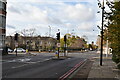
A207 Shooters Hill
The road is on the route of the Roman Watling Street.
Image: © Robin Webster
Taken: 14 Mar 2012
0.01 miles
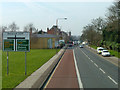
2
The Capital Ring (009)
The route turns eastwards onto Shooters Hill.
Image: © Shazz
Taken: 29 Mar 2019
0.02 miles
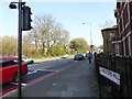
3
Shooters Hill police station
It is becoming increasingly rare to find a working police station nowadays, over half around north London are now empty.
Image: © David Howard
Taken: 18 May 2014
0.03 miles
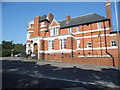
4
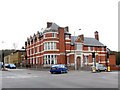
Old Bill Court, Shooters Hill
This police station closed c.2005 and was converted into flats, including some new extensions. The original name of the development was to have been "You're Nicked" but was changed to the less corny "Old Bill Court"
It is on a very busy junction of two A-roads (A205 South Circular Road and A207 Shooters Hill Road - the historic A2 or Dover Road).
Image: © Stephen Craven
Taken: 27 Feb 2011
0.03 miles
5
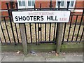
Vintage street nameplate, Shooters Hill
Image: © Chris Whippet
Taken: 23 Feb 2014
0.03 miles
6
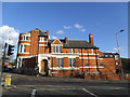
Former police station, Shooters Hill
The building has been in residential use for some years now. See Image
Image: © Stephen Craven
Taken: 16 Feb 2014
0.04 miles
7
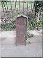
Old Boundary Marker by the A205, Academy Road, Woolwich
Estate Boundary Marker - War Department by the A205, in parish of Woolwich (Greenwich District), Academy Road SE18, at junction with the A207, Shooters Hill, against curved wall.
Surveyed
Milestone Society National ID: KE_WDRMAaem
Image: © Milestone Society
Taken: Unknown
0.04 miles
8
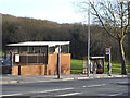
Bus stop on Well Hall Road
This stop is on the southbound side of the A205 South Circular Road and is served by routes 161 and 122.
Image: © Stephen Craven
Taken: 16 Feb 2014
0.05 miles
9
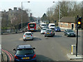
A207 junction with South Circular Road
Just an ordinary junction with traffic lights. The South Circular is a pale shadow of the North Circular.
Image: © Robin Webster
Taken: 14 Mar 2012
0.05 miles