IMAGES TAKEN NEAR TO
Shooters Hill, LONDON, SE18 3RU
Introduction
This page details the photographs taken nearby to Shooters Hill, SE18 3RU by members of the Geograph project.
The Geograph project started in 2005 with the aim of publishing, organising and preserving representative images for every square kilometre of Great Britain, Ireland and the Isle of Man.

There are currently over 7.5m images from over14,400 individuals and you can help contribute to the project by visiting https://www.geograph.org.uk
Image Map
Images are licensed for reuse under creativecommons.org/licenses/by-sa/2.0
Notes
- Clicking on the map will re-center to the selected point.
- The higher the marker number, the further away the image location is from the centre of the postcode.
Image Listing (148 Images Found)
Images are licensed for reuse under creativecommons.org/licenses/by-sa/2.0
Image
Details
Distance
4
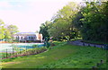
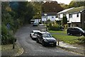
Off Shooter's Hill, London, SE18
The A207 lies a minute or two ahead. This service road links Shooter's Hill with the foot of Severndroog Castle (a Grade II* listed folly) 5 minutes walk away behind the photographer. The rear of Christchurch Primary School and its playground are also seen here.
Image: © David Hallam-Jones
Taken: 3 May 2014
0.04 miles
5
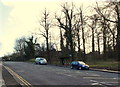
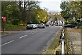
Shooter's Hill, London SE18
Eltham Common at the side of the Dover Road (the A207) opposite Constitution Rise. This is the view looking towards the summit of Shooter's Hill, with the Dover Road/the A207 leaving London, behind the photographer.
Image: © David Hallam-Jones
Taken: 2 Jan 2013
0.04 miles
6

Eltham Common, London SE18
A well-weathered, covered bench on the edge of Eltham Common at the side of the Dover Road (the A207) almost opposite Constitution Rise. This is the view looking towards the summit of Shooter's Hill.
Image: © David Hallam-Jones
Taken: 2 Jan 2013
0.05 miles
7
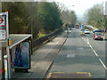
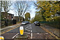
A207 Shooters Hill
From an 89 bus stopping at the westbound Memorial Hospital bus stop. A single-decker bus on route 244 is descending the hill ahead.
Image: © Robin Webster
Taken: 14 Mar 2012
0.05 miles
8

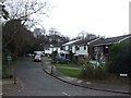
Shooter's Hill, London SE18
A glance down Shooter's Hill (Dover Road/A207) in the direction of the former Royal Herbert Army Hospital gives a view of Christ Church (Anglican) Voluntary- Aided Primary School. Despite the existence of a 'modern' extension on the left to the original school building on the right, recent pressure on its facilities led to Lakehouse plc securing a contract to build a further extension and a multi-use games area on an area of common land at the rear of the building in 2012, a scheme that met with a certain degree of resistance from some local inhabitants.
Image: © David Hallam-Jones
Taken: 2 Jan 2013
0.05 miles
9
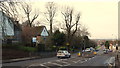
Shooter's Hill, London SE18
Christ Church Primary School (served by traffic lights) and The Red Lion pub against the right-hand margin of the picture. Eltham Common lies behind the school and the stretch of grass on the left is also part of this common land.
Image: © David Hallam-Jones
Taken: 2 Jan 2013
0.05 miles