IMAGES TAKEN NEAR TO
Nithdale Road, LONDON, SE18 3PA
Introduction
This page details the photographs taken nearby to Nithdale Road, SE18 3PA by members of the Geograph project.
The Geograph project started in 2005 with the aim of publishing, organising and preserving representative images for every square kilometre of Great Britain, Ireland and the Isle of Man.

There are currently over 7.5m images from over14,400 individuals and you can help contribute to the project by visiting https://www.geograph.org.uk
Image Map (Loading...)


Getting Data...Please wait
Leaflet Map data © OpenStreetMap
Images are licensed for reuse under creativecommons.org/licenses/by-sa/2.0
Notes
- Clicking on the map will re-center to the selected point.
- The higher the marker number, the further away the image location is from the centre of the postcode.
Image Listing (48 Images Found)
Images are licensed for reuse under creativecommons.org/licenses/by-sa/2.0
Image
Details
Distance
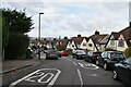
2
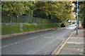
Brinklow Crescent
The slopes of Shooters Hill give wonderful views across London. This view looks across Plum Lane to the top of Brinklow Crescent.
Image: © Marathon
Taken: 9 Mar 2021
0.11 miles
3
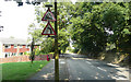
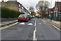
Plum Lane - Steep Hill 20%
Plum Lane, Plumstead. 20% steep hill down sign.
Image: © Adam Morse
Taken: 8 Aug 2009
0.12 miles
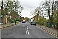
5
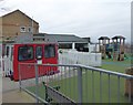
An unusual extra classroom
This can be spotted in the playground of Pumcroft School. It is half of a Tube carriage and has been set out inside as an extra teaching or learning space.
Image: © Marathon
Taken: 25 Dec 2018
0.12 miles
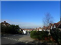
10
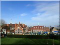
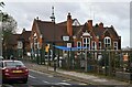
Plumcroft School
The views from the northern slopes of Shooters Hill are impressive. This looks down from a small open space to Plumcroft School.
Image: © Marathon
Taken: 20 Feb 2021
0.15 miles