IMAGES TAKEN NEAR TO
Vernham Road, LONDON, SE18 3EY
Introduction
This page details the photographs taken nearby to Vernham Road, SE18 3EY by members of the Geograph project.
The Geograph project started in 2005 with the aim of publishing, organising and preserving representative images for every square kilometre of Great Britain, Ireland and the Isle of Man.

There are currently over 7.5m images from over14,400 individuals and you can help contribute to the project by visiting https://www.geograph.org.uk
Image Map
Images are licensed for reuse under creativecommons.org/licenses/by-sa/2.0
Notes
- Clicking on the map will re-center to the selected point.
- The higher the marker number, the further away the image location is from the centre of the postcode.
Image Listing (83 Images Found)
Images are licensed for reuse under creativecommons.org/licenses/by-sa/2.0
Image
Details
Distance
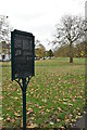
3
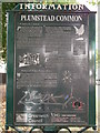
Plumstead Common Information Panel
Beside a footpath into the Common, from Plumstead Common Road.
Image: © David Anstiss
Taken: 21 Aug 2011
0.12 miles
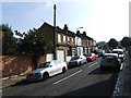
8
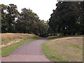
Path on Plumstead Common
This path leads from St.Margaret's Grove towards Blendon Terrace.
It is also used by the Green Chain Walk (long distance walk) heading through the various parts of Plumstead Common.
Image: © David Anstiss
Taken: 21 Aug 2011
0.13 miles
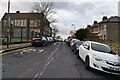
9
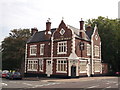
The Prince of Wales Public House, Woolwich
On the junction of St Margarets Grove (on the left) and Plumstead Common Road (on the right).
Image: © David Anstiss
Taken: 21 Aug 2011
0.13 miles