IMAGES TAKEN NEAR TO
Ashridge Crescent, LONDON, SE18 3EB
Introduction
This page details the photographs taken nearby to Ashridge Crescent, SE18 3EB by members of the Geograph project.
The Geograph project started in 2005 with the aim of publishing, organising and preserving representative images for every square kilometre of Great Britain, Ireland and the Isle of Man.

There are currently over 7.5m images from over14,400 individuals and you can help contribute to the project by visiting https://www.geograph.org.uk
Image Map
Images are licensed for reuse under creativecommons.org/licenses/by-sa/2.0
Notes
- Clicking on the map will re-center to the selected point.
- The higher the marker number, the further away the image location is from the centre of the postcode.
Image Listing (71 Images Found)
Images are licensed for reuse under creativecommons.org/licenses/by-sa/2.0
Image
Details
Distance
1
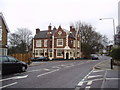
The "Prince of Wales", Plumstead Common Road, London SE18
This hostelry has a pleasant external appearance, and provided a welcome glass of brandy for your photographer on a cold March day.
Image: © Dr Neil Clifton
Taken: 27 Mar 2006
0.03 miles
2
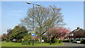
Mereworth Drive
A roundabout green halfway along the residential road which crosses the Shrewsbury Park estate.
Image: © Derek Harper
Taken: 17 Apr 2019
0.06 miles
3
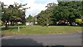
Green roundabout in the leafy Shrewsbury Park Estate
Image: © David Martin
Taken: 15 Sep 2014
0.06 miles
4
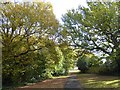
Path in Shrewsbury Park
Shrewsbury Park once formed part of the grounds of Shrewsbury House which is now a community centre to the south beyond the boundary of the park. Shrewsbury Park was purchased for public use by the London County Council in 1928. The Green Chain Walk passes through the park at the signpost seen in the distance.
A full history can be found at http://www.londongardensonline.org.uk/gardens-online-record.asp?ID=GRN061 and details of the Friends of Shrewsbury Park can be found at http://www.fspark.org.uk/
Image: © Marathon
Taken: 10 Nov 2017
0.07 miles
6
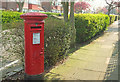
Postbox, Shrewsbury Park
George V postbox number SE18 72 is on Mereworth Drive.
Image: © Derek Harper
Taken: 17 Apr 2019
0.08 miles
7
Shrewsbury Park
Shrewsbury Park once formed part of the grounds of Shrewsbury House which is now a community centre to the south beyond the boundary of the park. Shrewsbury Park was purchased for public use by the London County Council in 1928. The Green Chain Walk passes through the park at the signpost just ahead.
A full history can be found at http://www.londongardensonline.org.uk/gardens-online-record.asp?ID=GRN061 and details of the Friends of Shrewsbury Park can be found at http://www.fspark.org.uk/
Image: © Marathon
Taken: 10 Nov 2017
0.09 miles
8
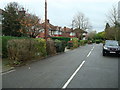
Ashridge Crescent, Shrewsbury Park Estate
Recent times have not generally been kind to the inter-war London private housing estates. They have become rather unfashionable compared to Victorian and Edwardian areas - the houses are often sub-divided and front gardens have mostly been converted into car parks. Many of the streets have a slightly neglected appearance. This estate in Shooters Hill is very much an exception with neat hedges, proper front gardens and plenty of evidence that residents have pride in their homes. Greenwich Council should be congratulated that the estate has been designated a conservation area.
The houses were built between 1934 and 1936 by John Laing and Son to a variety of standard designs - including both detached and semi-detached examples. Some have art deco features but all can be readily identified with their era. At the time the most expensive 'deluxe' houses sold for £820.
This view is looking into Ashridge Crescent from Mereworth Drive.
Image: © Stephen McKay
Taken: 20 Mar 2018
0.11 miles
9
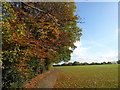
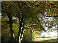
Autumn colours in Shrewsbury Park
Shrewsbury Park once formed part of the grounds of Shrewsbury House which is now a community centre to the south beyond the boundary of the park. Shrewsbury Park was purchased for public use by the London County Council in 1928. The Green Chain Walk passes through the park. There are fine views across the Thames into Essex from the grass area ahead.
A full history can be found at http://www.londongardensonline.org.uk/gardens-online-record.asp?ID=GRN061 and details of the Friends of Shrewsbury Park can be found at http://www.fspark.org.uk/
Image: © Marathon
Taken: 10 Nov 2017
0.11 miles
10
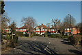
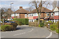
Houses in Shrewsbury Park
The junction of Ashridge Crescent with Mereworth Drive (left) and Kinlet Road (foreground).
Image: © Derek Harper
Taken: 23 Feb 2019
0.11 miles