IMAGES TAKEN NEAR TO
Cleanthus Road, LONDON, SE18 3DJ
Introduction
This page details the photographs taken nearby to Cleanthus Road, SE18 3DJ by members of the Geograph project.
The Geograph project started in 2005 with the aim of publishing, organising and preserving representative images for every square kilometre of Great Britain, Ireland and the Isle of Man.

There are currently over 7.5m images from over14,400 individuals and you can help contribute to the project by visiting https://www.geograph.org.uk
Image Map
Images are licensed for reuse under creativecommons.org/licenses/by-sa/2.0
Notes
- Clicking on the map will re-center to the selected point.
- The higher the marker number, the further away the image location is from the centre of the postcode.
Image Listing (130 Images Found)
Images are licensed for reuse under creativecommons.org/licenses/by-sa/2.0
Image
Details
Distance
1
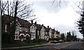
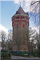
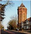
Shooter's Hill, Woolwich, London, SE18
The Grade II-listed octagonal water tower on Shooter's Hill seen from Cleanthus Road. The narrow footpath ahead has created two cul-de-sacs with an egg-timer type narrowing at the Shooter's Hill portion of the road.
Image: © David Hallam-Jones
Taken: 3 Apr 2013
0.02 miles
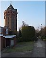
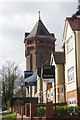
3
Water Tower, Shooters Hill
A grade II listed building of 1910.
Image: © Robin Webster
Taken: 14 Mar 2012
0.03 miles
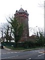
4
Shooters Hill Water Tower
This octagonal tower stands near the top of Shooters Hill. It was built in 1910 in a rather fanciful gothic style.
Image: © Stephen McKay
Taken: 20 Mar 2018
0.03 miles
5
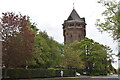
Shooters Hill water tower
A skyline landmark visible from far across southeast London, less due to its own height than its prominent position on the summit of Shooters Hill.
Image: © David Martin
Taken: 9 May 2021
0.03 miles
6
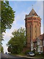
Water Tower, Shooters Hill
The octagonal water tower, also seen in http://www.geograph.org.uk/search.php?i=25011001 , was built in 1910 http://www.britishlistedbuildings.co.uk/en-396387-water-tower-at-east-side-of-junction-wit . This view is from the junction of Dover Road (visible) and Eaglesfield Road.
Image: © Derek Harper
Taken: 20 May 2006
0.03 miles
7
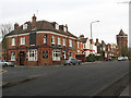
The Bull public house, Shooters Hill
The Bull stands on the corner of Shooters Hill and Shrewsbury Lane. A sign on the wall says there was a public house on the site since 1741 (when this was the main turnpike road from London to Dover), though the present building is Victorian. At the top of the hill in the background is the water tower Image
Image: © Stephen Craven
Taken: 24 Jan 2009
0.04 miles
8
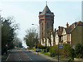
Shooter's Hill, Woolwich, London, SE18
These vehicles travelling in the direction of central London are about to reach the crown of Shooter's Hill having ascended the hill from the Welling and Bexleyheath direction. On the right, at the junction with Cleanthus Road, is a Grade II-listed octagonal water tower, built in 1910.
Image: © David Hallam-Jones
Taken: 3 Apr 2013
0.04 miles
9
Shooters Hill
Plenty of property to let here near the top of Shooters Hill - one of the highest points in London. The octagonal water tower dates from 1910.
Image: © Stephen McKay
Taken: 20 Mar 2018
0.04 miles