IMAGES TAKEN NEAR TO
Eaglesfield Road, LONDON, SE18 3BU
Introduction
This page details the photographs taken nearby to Eaglesfield Road, SE18 3BU by members of the Geograph project.
The Geograph project started in 2005 with the aim of publishing, organising and preserving representative images for every square kilometre of Great Britain, Ireland and the Isle of Man.

There are currently over 7.5m images from over14,400 individuals and you can help contribute to the project by visiting https://www.geograph.org.uk
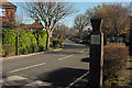
Image Map
Images are licensed for reuse under creativecommons.org/licenses/by-sa/2.0
Notes
- Clicking on the map will re-center to the selected point.
- The higher the marker number, the further away the image location is from the centre of the postcode.
Image Listing (73 Images Found)
Images are licensed for reuse under creativecommons.org/licenses/by-sa/2.0
Image
Details
Distance
1
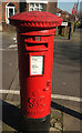
Postbox, Shrewsbury Park
Another view of George VI postbox SE18 22 Image The Green Chain Walk follows Kinlet Road on the right behind the box.
Image: © Derek Harper
Taken: 24 Feb 2019
0.02 miles
2
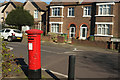
Postbox, Shrewsbury Park
George VI postbox SE18 22 is at the junction of Eaglesfield Road (in view) with Kinlet Road, which is followed by the Green Chain Walk.
Image: © Derek Harper
Taken: 24 Feb 2019
0.02 miles
3
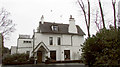
Entrance to Shrewsbury Park Estate Conservation Area
Image: © David Martin
Taken: 15 Sep 2014
0.04 miles
4
Cleanthus Road, Shooters Hill
The road heads towards Shooters Hill but there is a curious hiatus; its last 40 metres are offset and cannot be accessed from the rest of the road. You can get through on foot, though.
Image: © Derek Harper
Taken: 24 Feb 2019
0.05 miles
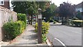
5
Kinlet Road, Shrewsbury Park
This must be the twin of Image on the other side of the road. Kinlet Road, carrying the Green Chain Walk, runs along the southeastern side of the conservation area, and the houses on the right back on to Shooters Hill golf course - see Image The estate was built in 1936.
Image: © Derek Harper
Taken: 24 Feb 2019
0.06 miles
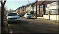
6
Eaglesfield Road, Shooters Hill
Seen from Cleanthus Road. In the background centre is the mast shown in Image
Image: © Derek Harper
Taken: 24 Feb 2019
0.07 miles
7
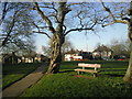
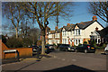
Eaglesfield Recreation Ground
This view looks across Eaglesfield Recreation Ground to the houses in Foxcroft Road. Eaglesfield Recreation Ground is situated on the upper slopes of Shooters Hill and provides fine views to the east.
Image: © Marathon
Taken: 7 Mar 2011
0.08 miles
8

Kinlet Road, SE18
On the Shrewsbury Park estate, Shooters Hill; the houses on the left back onto the golf course.
Image: © Derek Harper
Taken: 20 May 2006
0.08 miles
9
Shooters Hill Golf Club
My godfather was a life member of the club; this was taken on the day of his funeral, after which a wake was held here. His heyday was from 1952, when he won the Gold Medal Junior, to 1962, when he shared the pairs Clatsom Trophy.
"Golf was first played here in 1903 when a 3 hole course was opened. In 1907 a full 18 hole course was laid out" https://www.shgc.co.uk/the-club/club-history/ .
Image: © Derek Harper
Taken: 24 Jan 2019
0.08 miles
10
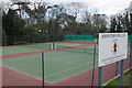
Shooters Hill Lawn Tennis Club
This tennis club, on Eaglesfield Road, was founded in 1927 as part of the Shooters Hill Golf Club. It became independent in 1967 and now has six floodlit all-weather courts. On this weekday afternoon none of them were being used.
Image: © Stephen McKay
Taken: 20 Mar 2018
0.09 miles