IMAGES TAKEN NEAR TO
Gilbourne Road, LONDON, SE18 2NT
Introduction
This page details the photographs taken nearby to Gilbourne Road, SE18 2NT by members of the Geograph project.
The Geograph project started in 2005 with the aim of publishing, organising and preserving representative images for every square kilometre of Great Britain, Ireland and the Isle of Man.

There are currently over 7.5m images from over14,400 individuals and you can help contribute to the project by visiting https://www.geograph.org.uk
Image Map
Images are licensed for reuse under creativecommons.org/licenses/by-sa/2.0
Notes
- Clicking on the map will re-center to the selected point.
- The higher the marker number, the further away the image location is from the centre of the postcode.
Image Listing (134 Images Found)
Images are licensed for reuse under creativecommons.org/licenses/by-sa/2.0
Image
Details
Distance
3
Swingate Lane, Plumstead
Swingate Lane is a residential road near Plumstead Common, in the suburbs of south east London.
Image: © Malc McDonald
Taken: 18 Sep 2021
0.07 miles
4
Bleak Hill Lane, Plumstead
The lane is the road going off to the left here, closed to motor traffic, and is the older road down into West Wickham, now replaced by the Kings Highway (foreground).
Image: © Stephen Craven
Taken: 1 Nov 2014
0.10 miles
5
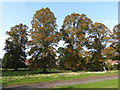
Autumn trees in Woolwich Old Cemetery
Woolwich Cemetery is in two parts, west and east, divided by Rockliffe Gardens. This is the Old Cemetery to the west, founded in 1856 by the Woolwich Burial Board. They laid out the 12-acre site which was formerly part of Plumstead Common. This is the cemetery at the end of September when the autumn colours seemed to be coming early.
Image: © Marathon
Taken: 26 Sep 2017
0.11 miles
6
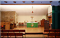
St Mark & St Margaret, Old Mill Road, Plumstead - East end
Image: © John Salmon
Taken: 9 Jul 2010
0.11 miles
7
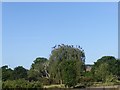
A bit like The Birds
This was fairly early in the morning looking across Bleak Hill Lane on Plumstead Common. The crows were constantly coming and going.
Image: © Marathon
Taken: 25 May 2020
0.12 miles
8
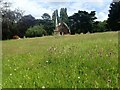
Woolwich Old Cemetery and the chapel
Woolwich Cemetery is in two parts, west and east, divided by Rockliffe Gardens. This is the Old Cemetery to the west, founded in 1856 by the Woolwich Burial Board. They laid out the 12-acre site which was formerly part of Plumstead Common.
In the distance is the chapel, a close up of which can be seen at http://www.geograph.org.uk/photo/2983511
Image: © Marathon
Taken: 13 Jul 2021
0.13 miles
9
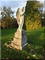
Flaunty memorial in Woolwich Old Cemetery
Woolwich Cemetery is in two parts, west and east, divided by Rockliffe Gardens. This is the Old Cemetery to the west, founded in 1856 by the Woolwich Burial Board. They laid out the 12-acre site which was formerly part of Plumstead Common.
This memorial in Woolwich Old Cemetery is to Margaret Flaunty who died in 1910 aged 57 and to her husband Edward who died in 1940 aged 87.
Image: © Marathon
Taken: 1 Nov 2020
0.13 miles
10
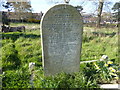
Infant mortality in the 19th century, Woolwich Old Cemetery
Woolwich Cemetery is in two parts, west and east, divided by Rockliffe Gardens. This is the Old Cemetery to the west, founded in 1856 by the Woolwich Burial Board. They laid out the 12-acre site which was formerly part of Plumstead Common.
This is a close up of the gravestone seen at https://www.geograph.org.uk/photo/6425114
Image: © Marathon
Taken: 26 Mar 2020
0.14 miles