IMAGES TAKEN NEAR TO
Highmead, LONDON, SE18 2DJ
Introduction
This page details the photographs taken nearby to Highmead, SE18 2DJ by members of the Geograph project.
The Geograph project started in 2005 with the aim of publishing, organising and preserving representative images for every square kilometre of Great Britain, Ireland and the Isle of Man.

There are currently over 7.5m images from over14,400 individuals and you can help contribute to the project by visiting https://www.geograph.org.uk
Image Map
Images are licensed for reuse under creativecommons.org/licenses/by-sa/2.0
Notes
- Clicking on the map will re-center to the selected point.
- The higher the marker number, the further away the image location is from the centre of the postcode.
Image Listing (297 Images Found)
Images are licensed for reuse under creativecommons.org/licenses/by-sa/2.0
Image
Details
Distance
1
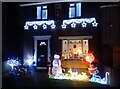
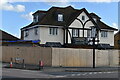
Christmas lights in Welling
There seemed to be more gardens lit up in 2020 than ever before.
Image: © Marathon
Taken: 17 Dec 2020
0.01 miles
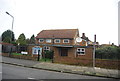
2
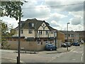
The former Glenmore Arms pub, Plumstead
Viewed from the top of a bus. The pub was apparently still open in August 2011 Image but has closed within the last ten years. This was the 'last pub in Greenwich' as immediately beyond the building is the boundary between Greenwich and Bexley boroughs.
Image: © Stephen Craven
Taken: 31 May 2022
0.07 miles
3
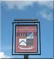
The Glenmore Arms, Pub Sign, Plumstead
Sign outside Image
Image: © David Anstiss
Taken: 7 Aug 2011
0.08 miles
4
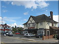
The Glenmore Arms, Public House, Plumstead
Pub on the junction of Edison Road (in front) and Combeside (behind).
Image: © David Anstiss
Taken: 7 Aug 2011
0.08 miles
5
Former pub being converted to apartments
The Glenmore Arms under redevelopment.
Image: © David Martin
Taken: 3 Oct 2021
0.08 miles
6
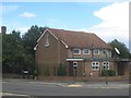
New Apostolic Church, Welling
Church on the corner of Dryden Road (in front) and Edison Road (on the left).
Image: © David Anstiss
Taken: 7 Aug 2011
0.10 miles
8
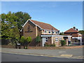
Church next to the Green Chain Walk
This is the New Apostolic Church on the corner of Dryden Road and Edison Road. See https://en.wikipedia.org/wiki/New_Apostolic_Church for more about the churches.
Image: © Marathon
Taken: 6 Oct 2017
0.10 miles
9
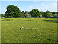
Buttercups in a horse pasture
This horse pasture is on the edge of East Wickham Open Space and is here seen from Camdale Road.
Image: © Marathon
Taken: 4 May 2020
0.11 miles
10
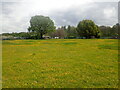
A field of buttercups
This horse pasture is next to Camdale Road. East Wickham Open Space is beyond the field.
Image: © Marathon
Taken: 13 May 2021
0.11 miles