IMAGES TAKEN NEAR TO
Grasdene Road, LONDON, SE18 2AT
Introduction
This page details the photographs taken nearby to Grasdene Road, SE18 2AT by members of the Geograph project.
The Geograph project started in 2005 with the aim of publishing, organising and preserving representative images for every square kilometre of Great Britain, Ireland and the Isle of Man.

There are currently over 7.5m images from over14,400 individuals and you can help contribute to the project by visiting https://www.geograph.org.uk
Image Map (Loading...)


Getting Data...Please wait
Leaflet Map data © OpenStreetMap
Images are licensed for reuse under creativecommons.org/licenses/by-sa/2.0
Notes
- Clicking on the map will re-center to the selected point.
- The higher the marker number, the further away the image location is from the centre of the postcode.
Image Listing (215 Images Found)
Images are licensed for reuse under creativecommons.org/licenses/by-sa/2.0
Image
Details
Distance
1
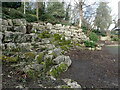
William Barefoot Gardens
William Barefoot Gardens were laid out in the 1930s and opened in 1942. At the entrance on Alliance Road are fine wrought iron gates with the Borough coat-of-arms. The site is steeply sloping and has an area of lawn at the base of the hill, with a path winding up through steep woodland and shrubbery to an entrance at the top of the hill, which leads directly into Woolwich New Cemetery. Woolwich New Cemetery is at the top of the hill on the left.
The gardens are named after William Barefoot (1872-1941) who had been Mayor of Woolwich in 1925-27. There is more about his life here https://en.wikipedia.org/wiki/William_Barefoot
Image: © Marathon
Taken: 31 Jan 2021
0.06 miles
2
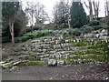
William Barefoot Gardens
William Barefoot Gardens were laid out in the 1930s and opened in 1942. At the entrance on Alliance Road are fine wrought iron gates with the Borough coat-of-arms. The site is steeply sloping and has an area of lawn at the base of the hill, with a path winding up through steep woodland and shrubbery to an entrance at the top of the hill, towards the left at the top of the gardens in this photograph. That entrance leads directly into Woolwich New Cemetery.
The gardens are named after William Barefoot (1872-1941) who had been Mayor of Woolwich in 1925-27. There is more about his life here https://en.wikipedia.org/wiki/William_Barefoot
Image: © Marathon
Taken: 28 Jan 2021
0.06 miles
3
William Barefoot Gardens
William Barefoot Gardens were laid out in the 1930s and opened in 1942. At the entrance on Alliance Road are fine wrought iron gates with the Borough coat-of-arms. The site is steeply sloping and has an area of lawn at the base of the hill, with a path winding up through steep woodland and shrubbery to an entrance at the top of the hill, which leads directly into Woolwich New Cemetery. This view looks up the path - Woolwich New Cemetery is at the top of the hill on the left.
The gardens are named after William Barefoot (1872-1941) who had been Mayor of Woolwich in 1925-27. There is more about his life here https://en.wikipedia.org/wiki/William_Barefoot
Image: © Marathon
Taken: 31 Jan 2021
0.06 miles
4
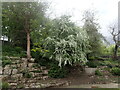
William Barefoot Gardens
William Barefoot Gardens were laid out in the 1930s and opened in 1942. At the entrance on Alliance Road are fine wrought iron gates with the Borough coat-of-arms. The site is steeply sloping and has an area of lawn at the base of the hill, with a path winding up through steep woodland and shrubbery to an entrance at the top of the hill, towards the left at the top of the gardens in this photograph. That entrance leads directly into Woolwich New Cemetery.
The gardens are named after William Barefoot (1872-1941) who had been Mayor of Woolwich in 1925-27. There is more about his life here https://en.wikipedia.org/wiki/William_Barefoot
Image: © Marathon
Taken: 22 May 2021
0.06 miles
5
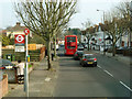
Littledale bus stops
On Wickham Lane, with a 96 bus leaving the southbound stop, viewed from another 96 bus.
Image: © Robin Webster
Taken: 14 Mar 2012
0.08 miles
6
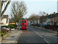
96 bus at Littledale bus stop
Going south on the A209.
Image: © Robin Webster
Taken: 14 Mar 2012
0.08 miles
7
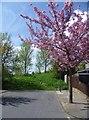
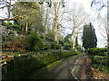
Blossom in Bournewood Road, Plumstead
This view looks towards East Wickham Open Space at the end of the road.
Image: © Marathon
Taken: 5 May 2013
0.08 miles
8
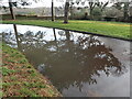
Woolwich New Cemetery
Woolwich Cemetery is in two parts, the Old Cemetery to the west and the New Cemetery to the east. The Old Cemetery was laid out by Woolwich Burial Board in 1856 and the land for the New Cemetery was purchased in 1885 and is still in use. It contains graves of those who died in explosions at the Royal Arsenal and a number of War Graves, including a holder of the Victoria Cross.
It was on the last day of January afternoon when this reflection in a flooded path was photographed. Bostall Woods can be seen in the distance across the Wickham Valley.
Image: © Marathon
Taken: 31 Jan 2021
0.09 miles
9
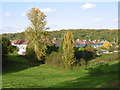
View from East Wickham Open Space
This former landfill site is now a fine open space on the borders of Plumstead and Welling. This view looks across the Wickham Valley to Bostall Woods.
Image: © Marathon
Taken: 20 Oct 2015
0.10 miles
10
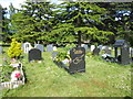
Cypriot section in Woolwich New Cemetery
Woolwich Cemetery is in two parts, the Old Cemetery to the west and the New Cemetery to the east. The Old Cemetery was laid out by Woolwich Burial Board in 1856 and the land for the New Cemetery was purchased in 1885 and is still in use. It contains graves of those who died in explosions at the Royal Arsenal, as well as the War Memorial and a number of War Graves, including one recipient of the Victoria Cross - see https://www.geograph.org.uk/photo/6462787
Image: © Marathon
Taken: 9 May 2020
0.10 miles