IMAGES TAKEN NEAR TO
Grosmont Road, LONDON, SE18 2AA
Introduction
This page details the photographs taken nearby to Grosmont Road, SE18 2AA by members of the Geograph project.
The Geograph project started in 2005 with the aim of publishing, organising and preserving representative images for every square kilometre of Great Britain, Ireland and the Isle of Man.

There are currently over 7.5m images from over14,400 individuals and you can help contribute to the project by visiting https://www.geograph.org.uk
Image Map
Images are licensed for reuse under creativecommons.org/licenses/by-sa/2.0
Notes
- Clicking on the map will re-center to the selected point.
- The higher the marker number, the further away the image location is from the centre of the postcode.
Image Listing (58 Images Found)
Images are licensed for reuse under creativecommons.org/licenses/by-sa/2.0
Image
Details
Distance
1
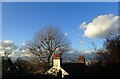
Chimney pots at Plumstead Common
This view is at the top of Grosmont Road where it reaches Winn Common Road. The views across London are extensive. The chimneys belong to a house at the top of Purrett Road.
Image: © Marathon
Taken: 5 Feb 2021
0.04 miles
2
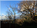
View at Plumstead Common
This view is at the top of Grosmont Road where it reaches Winn Common Road. The views across London are extensive.
Image: © Marathon
Taken: 5 Feb 2021
0.06 miles
3
Steps on the Green Chain Walk
These steep steps lead down through woodland from Winns Common which is part of Plumstead Common to Wickham Lane. Beyond Wickham Lane the Green Chain Walk leads up to Bostall Woods.
Image: © Marathon
Taken: 30 Apr 2020
0.08 miles
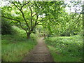
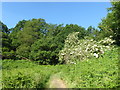
4
The Green Chain Walk on the way to Bostall Woods
This path leads down through woodland from Winns Common which is part of Plumstead Common to Wickham Lane. Beyond Wickham Lane the Green Chain Walk leads up to Bostall Woods.
Image: © Marathon
Taken: 30 Apr 2020
0.08 miles
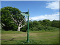
5
The Green Chain Walk on Winns Common
Plumstead Common was purchased for the people in 1877. Before that, the parish council had grazing rights and free access, even though the land was owned by Queens College, Oxford. From 1871 the College had allowed the Army access and it was largely turned into a military training ground. This led to a storm of protest and a procession to the Common took place. Their leader was temporarily imprisoned and further protest took place until an Act of Parliament authorised purchase of the Common by the Metropolitan Board of Works.
The eastern part of Plumstead Common is known as Winns Common and this part of the Common is characterised by steep roads leading down towards lower Plumstead and also steep slopes to the east and south. The Green Chain Walk straight ahead drops down through the woods of Bleak Hill to reach Wickham Lane before continuing on to reach Bostall Woods and Lesnes Abbey.
Image: © Marathon
Taken: 11 Nov 2016
0.08 miles
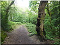
6
Path up on to Bleak Hill
These path leads on to steep steps up through the woodland ahead on the way from King's Highway to Winns Common, which in turn is part of Plumstead Common. It forms part of the Green Chain Walk.
Image: © Marathon
Taken: 25 May 2020
0.08 miles
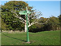
7
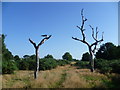
Green Chain Walk sign on Winns Common
Winns Common is the eastern part of Plumstead Common. The Green Chain Walk leads steeply downhill here beyond the dead tree to Wickham Lane and beyond there to Bostall Woods. See https://www.geograph.org.uk/photo/6461709
Image: © Marathon
Taken: 1 May 2020
0.09 miles
8
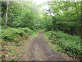
The Green Chain Walk descends from Winns Common
These steep steps lead down through woodland from Winns Common which is part of Plumstead Common to Wickham Lane. Beyond Wickham Lane the Green Chain Walk leads up to Bostall Woods.
Image: © Marathon
Taken: 30 Apr 2020
0.09 miles
9
Holly on Winns Common
Plumstead Common was purchased for the people in 1877. Before that, the parish council had grazing rights and free access, even though the land was owned by Queens College, Oxford. From 1871 the College had allowed the Army access and it was largely turned into a military training ground. This led to a storm of protest and a procession to the Common took place. Their leader was temporarily imprisoned and further protest took place until an Act of Parliament authorised purchase of the Common by the Metropolitan Board of Works.
The eastern part of Plumstead Common is known as Winns Common and this part of the Common is characterised by steep roads leading down towards lower Plumstead and also steep slopes to the east and south. This path along the top of the eastern edge passes this fine holly tree which was covered in berries.
Image: © Marathon
Taken: 11 Nov 2016
0.09 miles
10
Winn's Common
Winn's Common is the eastern part of Plumstead Common. Although this was once heathland there is now no heather to be found although plants such as gorse are still to be seen. However, names such as Heath Villas and Heathfield Terrace are reminders of what was once here. There are also tremendous views across the Thames basin. The areas of remnant heathland and woodland are around the fringes as here between Riverdale Road and Purrett Road. The photograph looks back towards the main common.
Image: © Marathon
Taken: 5 Sep 2012
0.10 miles