IMAGES TAKEN NEAR TO
Reidhaven Road, LONDON, SE18 1BN
Introduction
This page details the photographs taken nearby to Reidhaven Road, SE18 1BN by members of the Geograph project.
The Geograph project started in 2005 with the aim of publishing, organising and preserving representative images for every square kilometre of Great Britain, Ireland and the Isle of Man.

There are currently over 7.5m images from over14,400 individuals and you can help contribute to the project by visiting https://www.geograph.org.uk
Image Map
Images are licensed for reuse under creativecommons.org/licenses/by-sa/2.0
Notes
- Clicking on the map will re-center to the selected point.
- The higher the marker number, the further away the image location is from the centre of the postcode.
Image Listing (97 Images Found)
Images are licensed for reuse under creativecommons.org/licenses/by-sa/2.0
Image
Details
Distance
1
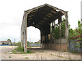
Derelict railway shed, Plumstead
This abandoned concrete-framed shed has overgrown railway tracks leading towards it from the adjacent Plumstead sidings Image It is wide enough to have housed two "roads" (tracks). But there are also references online to the Royal Arsenal's internal railway system having left the main line about this point, so I am unsure whether this a building would have belonged to British Rail or the military.
Image: © Stephen Craven
Taken: 9 May 2010
0.05 miles
2
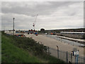
Entrance to Plumstead Crossrail site
Vehicular access from the Woolwich end of the site.
Image: © Stephen Craven
Taken: 19 Apr 2015
0.06 miles
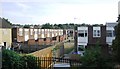
5
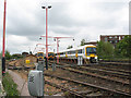
Plumstead railway sidings
These are the sidings seen also in Image from the road bridge. Trains out of London terminating at Plumstead are turned round and stored here: the one on the right here had just finished its run as the 11.53 from London Bridge to Plumstead.
The appearance of this site is likely to change when the Crossrail line emerges from a tunnel somewhere around here (c. 2015?)
Image: © Stephen Craven
Taken: 9 May 2010
0.06 miles
6
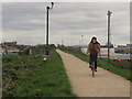
Cyclist on the Ridgeway
The recently improved surface now also has CCTV surveillance.
Image: © Stephen Craven
Taken: 19 Apr 2015
0.07 miles
7
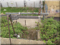
Access to the southern outfall sewer
The hoist equipment here shows that this is an access point to the twin sewers that run within the embankment.
Image: © Stephen Craven
Taken: 19 Apr 2015
0.08 miles
10
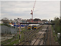
Sidings at Plumstead
Some trains terminate at Plumstead and are stored in these sidings awaiting their next duty Image Comparing this with my view nearly five years earlier Image, the main change is the Crossrail site now under construction to the left (north) of the main line. For a view in the opposite direction, showing the construction site more clearly, see Image
Image: © Stephen Craven
Taken: 19 Apr 2015
0.10 miles