IMAGES TAKEN NEAR TO
Orchard Road, LONDON, SE18 1BA
Introduction
This page details the photographs taken nearby to Orchard Road, SE18 1BA by members of the Geograph project.
The Geograph project started in 2005 with the aim of publishing, organising and preserving representative images for every square kilometre of Great Britain, Ireland and the Isle of Man.

There are currently over 7.5m images from over14,400 individuals and you can help contribute to the project by visiting https://www.geograph.org.uk
Image Map
Images are licensed for reuse under creativecommons.org/licenses/by-sa/2.0
Notes
- Clicking on the map will re-center to the selected point.
- The higher the marker number, the further away the image location is from the centre of the postcode.
Image Listing (88 Images Found)
Images are licensed for reuse under creativecommons.org/licenses/by-sa/2.0
Image
Details
Distance
3
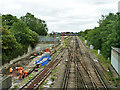
Railway east of Plumstead
Trenching work is going on by the line.
Image: © Robin Webster
Taken: 25 Jun 2011
0.05 miles
4
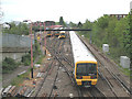
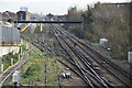
Railway east of Plumstead
The train is the 11.40 limited-stop Charing Cross to Gillingham service, next stop Abbey Wood. Some trains terminate at Plumstead and are stored in the sidings in the distance awaiting their next duty Image The track in the left foreground is only a short stub of track with a set of buffers which is why it has no power rail.
A site visitor with local knowledge has offered the following additional information:
The track in the left foreground is the last remnant of the connection from the 'Main Line' to the once extensive railway system in the Royal Arsenal works via the "Hole in the Wall" railway gate. It now serves as a 'Trap point' to ensure trains can't get onto the main line improperly, hence the lack of a conductor rail. The trees and bushes on the right are on the site of another siding which once served the needs of the Royal Arsenal Co-operative Society, a major retailer at one time in this part of SE London.
Image: © Stephen Craven
Taken: 9 May 2010
0.06 miles
5
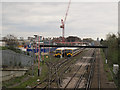
Sidings at Plumstead
Some trains terminate at Plumstead and are stored in these sidings awaiting their next duty Image Comparing this with my view nearly five years earlier Image, the main change is the Crossrail site now under construction to the left (north) of the main line. For a view in the opposite direction, showing the construction site more clearly, see Image
Image: © Stephen Craven
Taken: 19 Apr 2015
0.06 miles
7
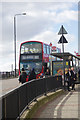
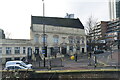
180 bus - Plumstead High Street
The 180 runs from Lewisham to Belvedere via Woolwich. Here it has paused at stop C, close to Plumstead station, to drop off some schoolgirls.
Image: © Stephen McKay
Taken: 20 Mar 2018
0.06 miles
8
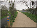
Crossness Ridgeway: start of the trail
The west end of the path at Plumstead after improvements in 2015, now clearly signed as shared-use. The path to the left comes up from for the lower level access to the west end of the route Image
Image: © Stephen Craven
Taken: 19 Apr 2015
0.07 miles
9
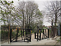
Crossness Ridgeway: west end barrier
As part of the improvements in 2015, the intermediate barriers were removed from the Ridgeway, and those at each end redesigned, to make it easier for cyclists to use the route, while still preventing motorcycle access.
See Image for the lower level access to the west end of the route.
Image: © Stephen Craven
Taken: 19 Apr 2015
0.07 miles