IMAGES TAKEN NEAR TO
Tewson Road, LONDON, SE18 1AY
Introduction
This page details the photographs taken nearby to Tewson Road, SE18 1AY by members of the Geograph project.
The Geograph project started in 2005 with the aim of publishing, organising and preserving representative images for every square kilometre of Great Britain, Ireland and the Isle of Man.

There are currently over 7.5m images from over14,400 individuals and you can help contribute to the project by visiting https://www.geograph.org.uk
Image Map (Loading...)


Getting Data...Please wait
Leaflet Map data © OpenStreetMap
Images are licensed for reuse under creativecommons.org/licenses/by-sa/2.0
Notes
- Clicking on the map will re-center to the selected point.
- The higher the marker number, the further away the image location is from the centre of the postcode.
Image Listing (56 Images Found)
Images are licensed for reuse under creativecommons.org/licenses/by-sa/2.0
Image
Details
Distance
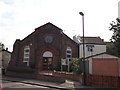
1
Christ the King Church, Plumstead
On the junction of Brewery Road (on the right) and Lakedale Road (on the left).
Image: © David Anstiss
Taken: 21 Aug 2011
0.04 miles
2
Christ the King Church (2), Plumstead
On the junction of Brewery Road (in front) and Lakedale Road (behind the church).
Image: © David Anstiss
Taken: 21 Aug 2011
0.05 miles
4
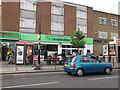
Tesco Express Plumstead
On the junction of Lakedale Road (in front) and Conway Road (unseen on the left).
Image: © David Anstiss
Taken: 21 Aug 2011
0.07 miles
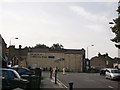
5
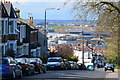
View down Lakedale Road
Her Majesty's Prison, Belmarsh is in the middle distance. The far distance is to the north of the Thames.
Image: © David Martin
Taken: 12 Apr 2016
0.09 miles
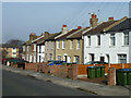
6
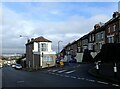
Lakedale Road, Plumstead
The roads leading down from Plumstead Common towards the Thames are very steep which makes many of the houses well above street level. This must make it very difficult to move furniture in and out. This is at the junction with Tewson Road which is on the right.
Image: © Marathon
Taken: 4 Feb 2021
0.09 miles
7
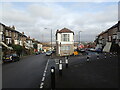
Lakedale Road, Plumstead
The roads leading down from Plumstead Common towards the Thames are very steep which makes many of the houses well above street level. This must make it very difficult to move furniture in and out. This is at the junction with Tewson Road which is on the right.
Image: © Marathon
Taken: 4 Feb 2021
0.10 miles
8
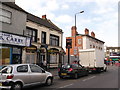
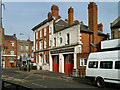
The Volunteer Public House, Plumstead
On the busy A206 Plumstead High Street.
Behind the white van is the Grade II listed Plumstead Fire Station.
Image: © David Anstiss
Taken: 21 Aug 2011
0.11 miles
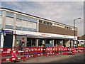
9
Plumstead Co-operative Supermarket
Part of a row of shops on Plumstead High Street, opposite Barth Road.
Image: © David Anstiss
Taken: 21 Aug 2011
0.11 miles
10
LCC Fire Brigade Station, Plvmstead
So says the inscription over the doors. It appears to be still operational, but presumably the fire brigade has a different title now. And hopefully they have dropped the affectation of using 'v' for 'u'.
Image: © Robin Webster
Taken: 14 Mar 2012
0.11 miles