IMAGES TAKEN NEAR TO
Carlisle Lane, LONDON, SE1 7LG
Introduction
This page details the photographs taken nearby to Carlisle Lane, SE1 7LG by members of the Geograph project.
The Geograph project started in 2005 with the aim of publishing, organising and preserving representative images for every square kilometre of Great Britain, Ireland and the Isle of Man.

There are currently over 7.5m images from over14,400 individuals and you can help contribute to the project by visiting https://www.geograph.org.uk
Image Map
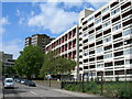
Images are licensed for reuse under creativecommons.org/licenses/by-sa/2.0
Notes
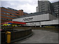
- Clicking on the map will re-center to the selected point.
- The higher the marker number, the further away the image location is from the centre of the postcode.
Image Listing (892 Images Found)
Images are licensed for reuse under creativecommons.org/licenses/by-sa/2.0
Image
Details
Distance
1
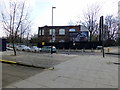
Derelict Building Founder?s Place London
Image: © PAUL FARMER
Taken: 17 Feb 2013
0.03 miles
2
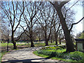
Archbishops' Park
London planes line the path. Now a public park, but, as the name suggests, originally part of the grounds of Lambeth Palace.
Image: © Stephen Richards
Taken: 20 Apr 2013
0.04 miles
3
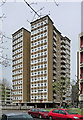
Stangate House, Royal Street
Good point block by William Howitt, 1963-64. Reinforced concrete frame, brick infill with decorative brickwork in the panels under the windows and mosaic tiles, the whole structure raised on pilotis. In plan it is quasi-butterfly-shaped.
Image: © Stephen Richards
Taken: 2 Apr 2011
0.04 miles
4
Zipwire in Lambeth Palace Gardens (2)
This is the view from the landing stage back to the start.
Image: © Shazz
Taken: 22 Sep 2017
0.04 miles
5
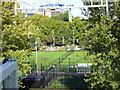
Royal Street, SE1
Showing an estate between St Thomas's Hospital and the railway line out of Waterloo.
Image: © Danny P Robinson
Taken: 11 May 2007
0.04 miles
6
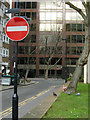
Upper Marsh, Lambeth
Upper Marsh is the poor relation of Lower Marsh; whereas Lower Marsh has an eclectic set of shops and cafes, as well as a street market, Upper Marsh winds between tower blocks and car parks before plunging under the throat of Waterloo station. It is seen here from the junction with the even more unlovely Royal Street with Becket House immediately ahead.
Image: © Stephen McKay
Taken: 20 Feb 2009
0.04 miles
7
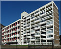
Canterbury House, Royal Street
Reinforced concrete frame. By Leslie Creed, Robert Maxwell and James Stirling, 1955-57, and evidently influenced by Le Corbusier's Unité d'Habitation in Marseilles.
Image: © Stephen Richards
Taken: 20 Apr 2013
0.04 miles
8
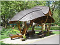
Archbishop's Park Bower
A hand carved seat and shelter in Archbishop's Park.
The bower was designed and hand-carved by local craftsman Arthur de Mowbray and completed in 2013.
The roof is red cedar and the seats and supports have been carved from a single oak tree.
Image: © John Illingworth
Taken: 9 May 2015
0.05 miles
9
A & E entrance ramp, St Thomas Hospital, Lambeth Palace Road SE1
Image: © Robin Sones
Taken: 13 Apr 2011
0.05 miles
10
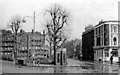
Lambeth Green on Lambeth Palace Road at York Road, 1950
View east, with St Thomas' Hospital behind camera. This was before major alterations here in the 1960s: expansion of St Thomas's Hospital, diversion of Lambeth Palace Road to bend eastward and abolition of the tramlines; also of the Mitre pub and of the phone-boxes. York Road no longer ends here, by the Mitre, but some way back and on the north side of Westminster Bridge Road.
Image: © Ben Brooksbank
Taken: 25 Mar 1950
0.05 miles