IMAGES TAKEN NEAR TO
Belvedere Road, LONDON, SE1 7GH
Introduction
This page details the photographs taken nearby to Belvedere Road, SE1 7GH by members of the Geograph project.
The Geograph project started in 2005 with the aim of publishing, organising and preserving representative images for every square kilometre of Great Britain, Ireland and the Isle of Man.

There are currently over 7.5m images from over14,400 individuals and you can help contribute to the project by visiting https://www.geograph.org.uk
Image Map
Images are licensed for reuse under creativecommons.org/licenses/by-sa/2.0
Notes
- Clicking on the map will re-center to the selected point.
- The higher the marker number, the further away the image location is from the centre of the postcode.
Image Listing (2940 Images Found)
Images are licensed for reuse under creativecommons.org/licenses/by-sa/2.0
Image
Details
Distance
1
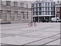
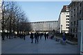
Belvedere Road
The Caravan procession of the Tour de France on the way to the start at Greenwich.
Image: © Mick Garratt
Taken: 8 Jul 2007
0.01 miles
2
The County Hall, Lambeth
This is a response to Pam Fray's photo http://www.geograph.org.uk/photo/1229255 of the County Hall just on the other side of the railway bridge carrying the railway into Waterloo station. View taken looking north-northwest from York Road in the direction of the London Eye, which is just around the corner to the right.
Image: © Robert Lamb
Taken: 25 Jul 2009
0.02 miles
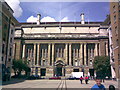
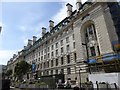
3
Main entrance, County Hall, Belvedere Road SE1
Taken from York Road, zoomed in across forecourt.
Image: © Robin Sones
Taken: 13 Apr 2011
0.02 miles
4
View of the office block on York Road from below the London Eye
Looking east.
Image: © Robert Lamb
Taken: 13 Mar 2016
0.02 miles
5
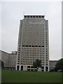
The Shell Centre Tower South Bank London
The tower forms part of the ‘Upstream Building’ It was constructed in 1961, to a design by Sir Howard Robertson, and the tower stands at 107 metres (351 ft) with 27 storeys. http://en.wikipedia.org/wiki/Shell_Centre
Image: © Richard Rogerson
Taken: 26 Jun 2009
0.02 miles
6
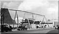
Festival of Britain Exhibition, 1951: north along York Road
View of the Exhibition under construction, from the corner of Chicheley Street: the old Shot Tower is visible in the background.
Image: © Ben Brooksbank
Taken: 21 Feb 1951
0.02 miles
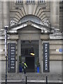
7
Former County Hall, now hotel
The London County Hall Marriott Hotel
Image: © David Smith
Taken: 11 Aug 2016
0.02 miles
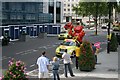
8
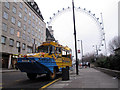
Miranda the duck takes a rest
A London "duck" (amphibious vehicle) out of service on Chicheley Street.
Image: © Stephen Craven
Taken: 12 Jan 2014
0.03 miles
9
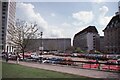
Looking south-east from Jubilee Gardens, 1989
The buildings closing off the view are, from left: the Shell Centre; Elizabeth House, at that time home to the Department of Education and Science; County Hall North Block; and County Hall itself.
The architect of Elizabeth House was the notorious John Poulson (1910-1993), better known for weaving a web of corruption in local government (https://en.wikipedia.org/wiki/John_Poulson ).
The vista here is now completely blocked by new development.
Image: © Christopher Hilton
Taken: 13 Apr 1989
0.03 miles