IMAGES TAKEN NEAR TO
Royal Street, LONDON, SE1 7EQ
Introduction
This page details the photographs taken nearby to Royal Street, SE1 7EQ by members of the Geograph project.
The Geograph project started in 2005 with the aim of publishing, organising and preserving representative images for every square kilometre of Great Britain, Ireland and the Isle of Man.

There are currently over 7.5m images from over14,400 individuals and you can help contribute to the project by visiting https://www.geograph.org.uk
Image Map
Images are licensed for reuse under creativecommons.org/licenses/by-sa/2.0
Notes
- Clicking on the map will re-center to the selected point.
- The higher the marker number, the further away the image location is from the centre of the postcode.
Image Listing (1034 Images Found)
Images are licensed for reuse under creativecommons.org/licenses/by-sa/2.0
Image
Details
Distance
1
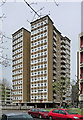
Stangate House, Royal Street
Good point block by William Howitt, 1963-64. Reinforced concrete frame, brick infill with decorative brickwork in the panels under the windows and mosaic tiles, the whole structure raised on pilotis. In plan it is quasi-butterfly-shaped.
Image: © Stephen Richards
Taken: 2 Apr 2011
0.02 miles
2
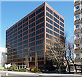
Becket House, Lambeth Palace Road
By Yorke, Rosenberg and Mardall, c1972. Slick, American-influenced with flush curtain walling, polished granite and bronzed-glass in aluminium frames.
Occupied by Ernst & Young at the time.
Image: © Stephen Richards
Taken: 20 Apr 2013
0.03 miles
4
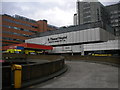
A & E entrance ramp, St Thomas Hospital, Lambeth Palace Road SE1
Image: © Robin Sones
Taken: 13 Apr 2011
0.03 miles
5
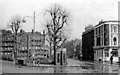
Lambeth Green on Lambeth Palace Road at York Road, 1950
View east, with St Thomas' Hospital behind camera. This was before major alterations here in the 1960s: expansion of St Thomas's Hospital, diversion of Lambeth Palace Road to bend eastward and abolition of the tramlines; also of the Mitre pub and of the phone-boxes. York Road no longer ends here, by the Mitre, but some way back and on the north side of Westminster Bridge Road.
Image: © Ben Brooksbank
Taken: 25 Mar 1950
0.03 miles
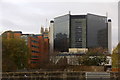
6
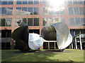
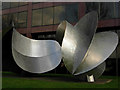
Sculpture outside Ernst & Young offices
Image: © Oast House Archive
Taken: 27 Jun 2015
0.03 miles
7
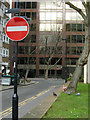
Upper Marsh, Lambeth
Upper Marsh is the poor relation of Lower Marsh; whereas Lower Marsh has an eclectic set of shops and cafes, as well as a street market, Upper Marsh winds between tower blocks and car parks before plunging under the throat of Waterloo station. It is seen here from the junction with the even more unlovely Royal Street with Becket House immediately ahead.
Image: © Stephen McKay
Taken: 20 Feb 2009
0.03 miles
8
Derelict Building Founder?s Place London
Image: © PAUL FARMER
Taken: 17 Feb 2013
0.03 miles
9
Big clue that might help date this photo
Taken outside St Thomas' Hospital, the bus publicises The Queen's 70th Jubilee https://en.wikipedia.org/wiki/Elizabeth_II#Platinum_Jubilee
Image: © Basher Eyre
Taken: 30 Jun 2022
0.04 miles
10
South of the River
This huge sculpture, entitled 'South of the River', was designed by Bernard Schottlander, cast by British Steel, and erected in 1976. It is not clear what it represents or why it stands on this patch of grass on Lambeth Palace Road outside Becket House, an otherwise undistinguished office block currently occupied by Ernst & Young, an international accountancy and tax consultancy firm.
Image: © Stephen McKay
Taken: 20 Feb 2009
0.04 miles