IMAGES TAKEN NEAR TO
McAuley Close, LONDON, SE1 7BX
Introduction
This page details the photographs taken nearby to McAuley Close, SE1 7BX by members of the Geograph project.
The Geograph project started in 2005 with the aim of publishing, organising and preserving representative images for every square kilometre of Great Britain, Ireland and the Isle of Man.

There are currently over 7.5m images from over14,400 individuals and you can help contribute to the project by visiting https://www.geograph.org.uk
Image Map
Images are licensed for reuse under creativecommons.org/licenses/by-sa/2.0
Notes
- Clicking on the map will re-center to the selected point.
- The higher the marker number, the further away the image location is from the centre of the postcode.
Image Listing (571 Images Found)
Images are licensed for reuse under creativecommons.org/licenses/by-sa/2.0
Image
Details
Distance
1
Ordnance Survey Bench mark
Flush Bracket "FL BR G5139 KENNINGTON POL STA S ANG SW FACE 3.6821m 0.0metres above ground"
Image: © The Saunterer
Taken: 21 Nov 2012
0.02 miles
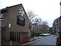
3
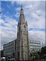
Christchurch & Upton Chapel, Lambeth North, London.
Built 1873. It was destroyed by bombing in 1940 but the tower was retained in the new chapel and office development. It is now the home of an "internet church" - "church.co.uk"
Image: © Stuart Taylor
Taken: 13 Jun 2005
0.02 miles
4
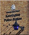
The Blue Lamp
Iconic lamp at London's Kennington Police Station.
Image: © Colin Smith
Taken: 1 Mar 2015
0.02 miles
5
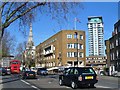
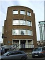
London - Lambeth
Kennington Police Station flanked by religious and secular towers.
Image: © Colin Smith
Taken: 1 Mar 2015
0.02 miles
6
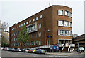
Police station, Kennington Road
Being essentially brick, but with a regular grid of stone-framed windows and pilotis at the entrance suggest this was built in the mid to late 1950s. It's quite attractive in its own way, especially with the gently-curved end.
Image: © Stephen Richards
Taken: 2 Apr 2011
0.03 miles
7
McCauley Close Lambeth
McCauley Close leads to the William Blake Estate from Cosser Street
Image: © PAUL FARMER
Taken: 14 Feb 2010
0.03 miles
8
Kennington Police Station
On Kennington Road at Mead Row.
Image: © Thomas Nugent
Taken: 24 Jan 2009
0.03 miles
9
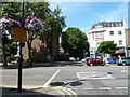
Looking from Mead Row across Kennington Road towards Cosser Street
Image: © Basher Eyre
Taken: 10 Jul 2010
0.03 miles
10
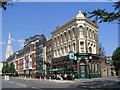
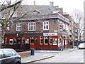
Pineapple Public House, Hercules Road
The church in the background is Image
Image: © Stephen Craven
Taken: 2 Jun 2007
0.04 miles