IMAGES TAKEN NEAR TO
Hillingdon Street, LONDON, SE17 3UW
Introduction
This page details the photographs taken nearby to Hillingdon Street, SE17 3UW by members of the Geograph project.
The Geograph project started in 2005 with the aim of publishing, organising and preserving representative images for every square kilometre of Great Britain, Ireland and the Isle of Man.

There are currently over 7.5m images from over14,400 individuals and you can help contribute to the project by visiting https://www.geograph.org.uk
Image Map
Images are licensed for reuse under creativecommons.org/licenses/by-sa/2.0
Notes
- Clicking on the map will re-center to the selected point.
- The higher the marker number, the further away the image location is from the centre of the postcode.
Image Listing (104 Images Found)
Images are licensed for reuse under creativecommons.org/licenses/by-sa/2.0
Image
Details
Distance
1
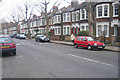
Victorian houses on John Ruskin Street, London
Image: © Oast House Archive
Taken: 9 Jan 2005
0.06 miles
2
Lorrimore Road, Walworth
Seen from Chapter Road with the former Duke of Sutherland pub on the corner of Draco Street.
Image: © Stephen McKay
Taken: 22 May 2012
0.07 miles
3
Lorrimore Road, Kennington ? 1966
View towards St Wilfred Church
Image: © Alan Murray-Rust
Taken: 25 Apr 1966
0.08 miles
4
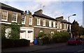
Victorian terrace, Lorrimore Road
Part of a terrace of 14 houses, with distinctive entrance link blocks http://www.britishlistedbuildings.co.uk/en-471076-48-74-camberwell .
Image: © Derek Harper
Taken: 17 Oct 2011
0.08 miles
5

Lorrimore Road
The name comes from the fact that this was at the south-west edge of the former Lorrimore (or Lower-moor) Common which was enclosed in 1769. The restored terrace seen here dates from 1852. The church in the distance is St Wilfrid's, a Roman Catholic church dating from 1915.
Image: © Marathon
Taken: 23 Nov 2011
0.08 miles
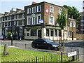
6
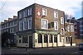
The Duke of Sutherland Public House, Kennington
On the junction of Draco Road (on the right) and Lorrimore Road (in front).
Image: © David Anstiss
Taken: 27 Nov 2009
0.09 miles
7
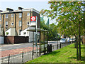
Chapter Road, Walworth
The bus stop is served by route P5 which wanders around inner south London indirectly linking Elephant & Castle with the Patmore Estate in Battersea.
Image: © Stephen McKay
Taken: 22 May 2012
0.09 miles
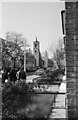
8

St. Wilfrids Church, Kennington Park
On Lorrimore Road.
Image: © David Anstiss
Taken: 27 Nov 2009
0.09 miles
10
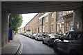
Grosvenor Terrace, Walworth, south London
The view from beneath bridge 373 HHH.
Image: © Robin Stott
Taken: 27 Aug 2016
0.11 miles