IMAGES TAKEN NEAR TO
Delverton Road, LONDON, SE17 3QQ
Introduction
This page details the photographs taken nearby to Delverton Road, SE17 3QQ by members of the Geograph project.
The Geograph project started in 2005 with the aim of publishing, organising and preserving representative images for every square kilometre of Great Britain, Ireland and the Isle of Man.

There are currently over 7.5m images from over14,400 individuals and you can help contribute to the project by visiting https://www.geograph.org.uk
Image Map (Loading...)


Getting Data...Please wait
Leaflet Map data © OpenStreetMap
Images are licensed for reuse under creativecommons.org/licenses/by-sa/2.0
Notes
- Clicking on the map will re-center to the selected point.
- The higher the marker number, the further away the image location is from the centre of the postcode.
Image Listing (186 Images Found)
Images are licensed for reuse under creativecommons.org/licenses/by-sa/2.0
Image
Details
Distance
1
A patch of purple in Kennington
Wisteria floribunda [Japanese Wisteria] on a house wall at the junction of Delverton and Tarver Roads.
Image: © Christine Johnstone
Taken: 22 Apr 2015
0.02 miles
2
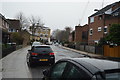
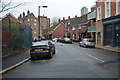
Three types of housing, Delverton Road, Kennington
Modern and lived in at the corner of Tarver Road. Older and being repaired or redeveloped at the corner of Manor Place. Oldest and boarded up across Manor Place.
Image: © Christine Johnstone
Taken: 22 Apr 2015
0.04 miles
3
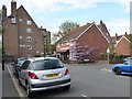
Unusual neighbours in Kennington
In the foreground - Walworth Garden Farm, a charitable horticultural training centre. In the background - the Army Centre, a former World War One drill hall.
Image: © Christine Johnstone
Taken: 22 Apr 2015
0.04 miles
5
Vote Labour in Kennington's Braganza Street
Between the houses looms part of Lambeth's former World War One drill hall.
Image: © Christine Johnstone
Taken: 22 Apr 2015
0.05 miles
6
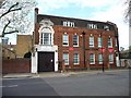
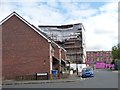
The Army Centre, Braganza Street, Kennington
Amongst other things, currently used as 256 (City of London) Field Hospital Regimental Headquarters. Formerly Lambeth's World War One Drill Hall. This is the south-west side of a large complex.
Image: © Christine Johnstone
Taken: 22 Apr 2015
0.05 miles
7
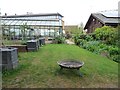
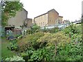
Walworth Garden Farm, Kennington
Seen from Braganza Street. Walworth Garden Farm is a local Charity that has been in operation since 1987. It provides environmental education, training in horticulture, garden maintenance services, workshops and courses including beekeeping.
Image: © Christine Johnstone
Taken: 22 Apr 2015
0.06 miles
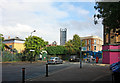
9
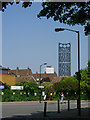
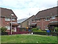
Manor Place, Walworth
Manor Place is overlooked by Strata SE1 at the Elephant & Castle - the tallest residential block in London.
Image: © Stephen McKay
Taken: 22 May 2012
0.06 miles