IMAGES TAKEN NEAR TO
Danson Mews, LONDON, SE17 3FL
Introduction
This page details the photographs taken nearby to Danson Mews, SE17 3FL by members of the Geograph project.
The Geograph project started in 2005 with the aim of publishing, organising and preserving representative images for every square kilometre of Great Britain, Ireland and the Isle of Man.

There are currently over 7.5m images from over14,400 individuals and you can help contribute to the project by visiting https://www.geograph.org.uk
Image Map (Loading...)


Getting Data...Please wait
Leaflet Map data © OpenStreetMap
Images are licensed for reuse under creativecommons.org/licenses/by-sa/2.0
Notes
- Clicking on the map will re-center to the selected point.
- The higher the marker number, the further away the image location is from the centre of the postcode.
Image Listing (212 Images Found)
Images are licensed for reuse under creativecommons.org/licenses/by-sa/2.0
Image
Details
Distance
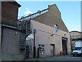
1
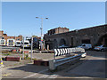
Manor Place council depot
The site will close if a proposed redevelopment of the area goes ahead (see shared description below). The viaduct in the background, which crosses the middle of the council site, is the main "Thameslink" railway south from Blackfriars.
Image: © Stephen Craven
Taken: 29 Apr 2015
0.02 miles
4
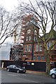
Former Manor Place baths (1)
Difficult to see behind the row of mature street trees, this is the large office block "composed from a variety of Arts and Crafts and Flemish Renaissance elements" that stands in front of the bath house itself. It was built in 1895, by architect L B L'Anson for the Parish of St Mary Newington (at that time the Vestry, or parish council, carried out many of the functions of a local authority). It is now listed grade 2, from which this description is extracted.
At least part of the office block is now a Buddhist centre (see shared description below).
Image: © Stephen Craven
Taken: 29 Apr 2015
0.03 miles
5
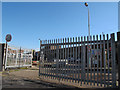
Gates to Manor Place council depot
The site will close if a proposed redevelopment of the area goes ahead (see shared description below).
Image: © Stephen Craven
Taken: 29 Apr 2015
0.03 miles
6
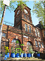
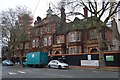
Former Manor Place baths (2)
The former main entrance and clock tower of the bath house, at least part of which is now a Buddhist centre (see shared description below).
Image: © Stephen Craven
Taken: 29 Apr 2015
0.03 miles
7
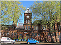
Former Manor Place baths (3)
The former main entrance and clock tower of the bath house, at least part of which is now a Buddhist centre (see shared description below).
Image: © Stephen Craven
Taken: 29 Apr 2015
0.03 miles
8

Former Manor Place baths - clock
The clock dial of the bath house.
Image: © Stephen Craven
Taken: 29 Apr 2015
0.03 miles
9
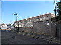
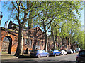
Buildings on the west side of Occupation Road
This side of the road is within the area currently proposed for redevelopment. This modern single-storey building appears to be one of the many sites of St Mungos Broadway (a charity for the homeless).
Image: © Stephen Craven
Taken: 29 Apr 2015
0.03 miles
10
Former Manor Place baths (4)
Looking through the back gate of the council depot, the old bath house could still be glimpsed.
Image: © Stephen Craven
Taken: 29 Apr 2015
0.03 miles