IMAGES TAKEN NEAR TO
Carter Street, LONDON, SE17 3EW
Introduction
This page details the photographs taken nearby to Carter Street, SE17 3EW by members of the Geograph project.
The Geograph project started in 2005 with the aim of publishing, organising and preserving representative images for every square kilometre of Great Britain, Ireland and the Isle of Man.

There are currently over 7.5m images from over14,400 individuals and you can help contribute to the project by visiting https://www.geograph.org.uk
Image Map
Images are licensed for reuse under creativecommons.org/licenses/by-sa/2.0
Notes
- Clicking on the map will re-center to the selected point.
- The higher the marker number, the further away the image location is from the centre of the postcode.
Image Listing (146 Images Found)
Images are licensed for reuse under creativecommons.org/licenses/by-sa/2.0
Image
Details
Distance
1
Trees on Chapter Road
A view from the roof of St Paul's church, Lorrimore Square, Newington. The Shard is clearly visible from here, and the Strata tower appears behind the trees.
Image: © Stephen Craven
Taken: 31 Oct 2012
0.04 miles
2
Saint Paul's Church, Lorrimore Square - seen from Chapter Road
In Lorrimore Square. Under the diocese of Southwark.
Image: © David Anstiss
Taken: 27 Nov 2009
0.05 miles
3
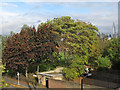
Pasley Park
This unassuming small park, tucked away in the back streets between Walworth and Kennington, was for a period in the 19th century home to the Royal Surrey Zoological Gardens housing all sorts of exotic animals. The zoo closed in 1856.
Image: © Stephen McKay
Taken: 22 May 2012
0.05 miles

5
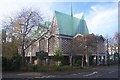
St Paul's Church, Lorrimore Square London
St Paul's was destroyed by enemy bombs during the Second World War. When the church was rebuilt this futuristic design was created. The place of worship is on the first floor and ground floor became an easily accessible day centre. The roof is built of copper.
Image: © PAUL FARMER
Taken: 26 Mar 2010
0.05 miles
6

St Paul, Lorrimore Square, London SE17 - West end
Image: © John Salmon
Taken: 16 Oct 2010
0.05 miles
7
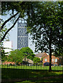
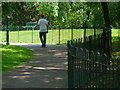
Pasley Park
The Strata SE1, completed in 2010 with its three wind turbines at the top, overlooks Pasley Park seen here from Chapter Road.
Image: © Stephen McKay
Taken: 22 May 2012
0.06 miles
8

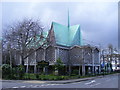
Saint Paul's Lorrimore Square, seen from west side
In the middle of Lorrimore Square. In the diocese of Southwark.
Image: © David Anstiss
Taken: 27 Nov 2009
0.06 miles

10

St Paul, Lorrimore Square, London SE17
Image: © John Salmon
Taken: 16 Oct 2010
0.06 miles