IMAGES TAKEN NEAR TO
Penrose Street, LONDON, SE17 3EA
Introduction
This page details the photographs taken nearby to Penrose Street, SE17 3EA by members of the Geograph project.
The Geograph project started in 2005 with the aim of publishing, organising and preserving representative images for every square kilometre of Great Britain, Ireland and the Isle of Man.

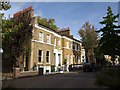
There are currently over 7.5m images from over14,400 individuals and you can help contribute to the project by visiting https://www.geograph.org.uk
Image Map
Images are licensed for reuse under creativecommons.org/licenses/by-sa/2.0
Notes
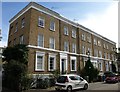
- Clicking on the map will re-center to the selected point.
- The higher the marker number, the further away the image location is from the centre of the postcode.
Image Listing (208 Images Found)
Images are licensed for reuse under creativecommons.org/licenses/by-sa/2.0
Image
Details
Distance
1
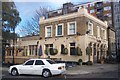
The Beehive Public House, Kennington
On Penrose Street, opposite Carter Street. Penrose Grove is in the background.
Image: © David Anstiss
Taken: 27 Nov 2009
0.00 miles
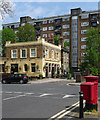
2
The Beehive, Fielding Street
The surroundings of The Beehive have certainly changed since it was first built.
Image: © Marathon
Taken: 23 Nov 2011
0.03 miles
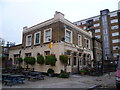
3
The Beehive, Carter Street
Victorian corner pub, probably built around the same time as the mid C19th housing behind the photographer.
The flats behind the pub are the mid C20th Penrose House.
Image: © Stephen Richards
Taken: 6 May 2013
0.03 miles
4
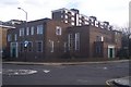
Surrey Gardens Memorial Hall
On Penrose Street, near the junction for Sturgeon Road. Penrose Grove is in the background.
Image: © David Anstiss
Taken: 27 Nov 2009
0.04 miles
5
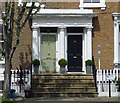
Detail of 36-37 Sutherland Square
Paired doors set between Doric columns and under a prominent triglyph frieze. Late Georgian.
Image: © Stephen Richards
Taken: 6 May 2013
0.05 miles
6
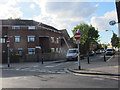
Southern end of Penton Place, Walworth
No entry except for cycles.
Image: © Stephen Craven
Taken: 29 Apr 2015
0.05 miles
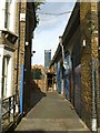
7
Penrose Grove, Walworth
Some of the arches of the adjacent Thameslink railway viaduct are used by a MOT centre.
Image: © Stephen Craven
Taken: 29 Apr 2015
0.06 miles
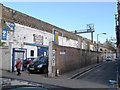
8
By the railway, SE17
Workshops use the arches beenath the viaduct carrying railway line the between Loughborough Junction and Elephant & Castle. In the background is the Strata Tower at the latter.
Image: © Derek Harper
Taken: 17 Oct 2011
0.06 miles
9
Terrace, Sutherland Square SE17
This terrace of six houses, dating from the early C19 http://www.britishlistedbuildings.co.uk/en-471376-numbers-55-60-and-attached-railings-55-6 , faces the west end of the square.
Image: © Derek Harper
Taken: 17 Oct 2011
0.06 miles
10
Houses on Sutherland Square, SE17
Beyond this short terrace with its impressive rows of chimney pots, the railway bridge carrying the line between Loughborough Junction and Elephant & Castle is almost hiddn by trees.
Image: © Derek Harper
Taken: 17 Oct 2011
0.06 miles