IMAGES TAKEN NEAR TO
Phelp Street, LONDON, SE17 2PL
Introduction
This page details the photographs taken nearby to Phelp Street, SE17 2PL by members of the Geograph project.
The Geograph project started in 2005 with the aim of publishing, organising and preserving representative images for every square kilometre of Great Britain, Ireland and the Isle of Man.

There are currently over 7.5m images from over14,400 individuals and you can help contribute to the project by visiting https://www.geograph.org.uk
Image Map
Images are licensed for reuse under creativecommons.org/licenses/by-sa/2.0
Notes
- Clicking on the map will re-center to the selected point.
- The higher the marker number, the further away the image location is from the centre of the postcode.
Image Listing (146 Images Found)
Images are licensed for reuse under creativecommons.org/licenses/by-sa/2.0
Image
Details
Distance
1
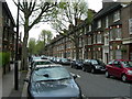
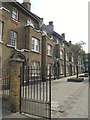
Merrow Street SE17
These are purpose built flats.
Image: © Danny P Robinson
Taken: 7 May 2006
0.06 miles
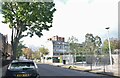
4
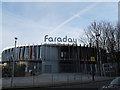
Michael Faraday School, Walworth
This primary school has been rebuilt in recent years and has quite a striking entrance. Website: http://michaelfaradayschool.co.uk/
Image: © Stephen Craven
Taken: 10 Dec 2011
0.08 miles
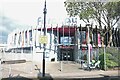
6
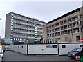
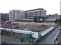
Aylesbury Estate regeneration
The Aylesbury Estate, built in the 1960s and 1970s, is a large estate of council housing. It is now undergoing regeneration, which will take around 15 years to complete.
The new block nearest the camera is one of the first to be completed, in late 2010. The first residents are due to move in in early 2011. In the background is Bradenham, one of the high-rise blocks, which is eventually likely to be demolished.
Image: © Malc McDonald
Taken: 22 Jan 2011
0.08 miles
7
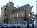
Walworth Telephone Exchange
Situated in Merrow Street, SE17 2NJ, this TE has 0207-701, 703 and 708 numbers. The former TE in adjacent Liverpool Grove, which used to have RODney numbers until the late 1960s, has been converted into flats.
Image: © David Hillas
Taken: 11 Nov 2008
0.10 miles
8
Housing on Portland Street, Walworth
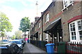
The housing on this road is quite distinctive. It forms part of the historic Octavia Hill estate (c.1905) - some of the houses are now listed although these on the corner of Merrow Street are not.
Image: © Stephen Craven
Taken: 21 Oct 2014
0.10 miles
9
Worth Grove, SE17
Part of an estate of flats between Liverpool Grove and Merrow Street.
Image: © Derek Harper
Taken: 17 Oct 2011
0.11 miles
10
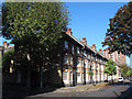
Aylesbury Estate regeneration
The Aylesbury Estate in south-east London was a large council estate developed in the 1960s and 1970s, housing around 7,500 people. The estate is now undergoing regeneration, which is likely to be ongoing until 2020 and beyond. One of the first parts of the estate to be demolished and rebuilt was the south-westernmost corner, with the first block completed in late 2010. The first residents are due to move into the new flats early in 2011. More homes are likely to be built on the site in the foreground.
This photo was taken from one of the walkways which linked blocks within the estate.
Image: © Malc McDonald
Taken: 22 Jan 2011
0.11 miles