IMAGES TAKEN NEAR TO
Westmoreland Road, LONDON, SE17 2BY
Introduction
This page details the photographs taken nearby to Westmoreland Road, SE17 2BY by members of the Geograph project.
The Geograph project started in 2005 with the aim of publishing, organising and preserving representative images for every square kilometre of Great Britain, Ireland and the Isle of Man.

There are currently over 7.5m images from over14,400 individuals and you can help contribute to the project by visiting https://www.geograph.org.uk
Image Map
Images are licensed for reuse under creativecommons.org/licenses/by-sa/2.0
Notes
- Clicking on the map will re-center to the selected point.
- The higher the marker number, the further away the image location is from the centre of the postcode.
Image Listing (181 Images Found)
Images are licensed for reuse under creativecommons.org/licenses/by-sa/2.0
Image
Details
Distance
1
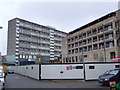
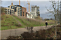
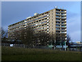
Aylesbury Estate regeneration
The Aylesbury Estate, built in the 1960s and 1970s, is a large estate of council housing. It is now undergoing regeneration, which will take around 15 years to complete.
The new block nearest the camera is one of the first to be completed, in late 2010. The first residents are due to move in in early 2011. In the background is Bradenham, one of the high-rise blocks, which is eventually likely to be demolished.
Image: © Malc McDonald
Taken: 22 Jan 2011
0.04 miles
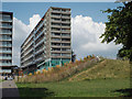
2
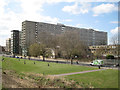
High-rise Bradenham and low-rise Chartridge, Aylesbury Estate, Walworth, London
The scale of the Aylesbury Estate is breathtaking. I wonder how it feels to live in it and be dwarfed by it. The view is from one of the bulldozer-formed mounds in Burgess Park.
Image: © Robin Stott
Taken: 5 Apr 2016
0.04 miles
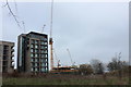
3
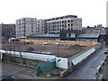
Aylesbury Estate regeneration
The Aylesbury Estate in south-east London was a large council estate developed in the 1960s and 1970s, housing around 7,500 people. The estate is now undergoing regeneration, which is likely to be ongoing until 2020 and beyond. One of the first parts of the estate to be demolished and rebuilt was the south-westernmost corner, with the first block completed in late 2010. The first residents are due to move into the new flats early in 2011. More homes are likely to be built on the site in the foreground.
This photo was taken from one of the walkways which linked blocks within the estate.
Image: © Malc McDonald
Taken: 22 Jan 2011
0.06 miles
5
New-build flats overlooking the western end of Burgess Park
Historic maps show this spot as Addington Wharf, at the very end of the former Surrey Canal.
Image: © David Martin
Taken: 29 Jan 2023
0.09 miles
7
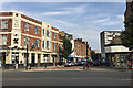
Westmoreland Street and the Red Lion pub, Walworth, south London
A wall of maisonettes on the Aylesbury Estate can be seen. The whole pub is seen in Image
Image: © Robin Stott
Taken: 27 Aug 2016
0.09 miles
8
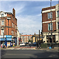
Arnside Street, Walworth, south London
Seen across the north end of Camberwell Road. On the right is the Red Lion pub Image
Image: © Robin Stott
Taken: 27 Aug 2016
0.10 miles
9
Chilton House, Southwark
A block of Southwark Council offices on Portland Street, seen across Burgess Park.
Image: © Stephen Craven
Taken: 1 Feb 2014
0.11 miles
10
One of the manmade knolls, western end of Burgess Park, Camberwell
In a flat part of London these man-made knolls form a large-scale rhythm at the entrance to Burgess Park. They lighten the mood and partly screen the built-up surroundings. In the background is a slab of council offices http://www.geograph.org.uk/photo/3833155
Image: © Robin Stott
Taken: 25 Aug 2013
0.11 miles