IMAGES TAKEN NEAR TO
Hopwood Road, LONDON, SE17 2BW
Introduction
This page details the photographs taken nearby to Hopwood Road, SE17 2BW by members of the Geograph project.
The Geograph project started in 2005 with the aim of publishing, organising and preserving representative images for every square kilometre of Great Britain, Ireland and the Isle of Man.

There are currently over 7.5m images from over14,400 individuals and you can help contribute to the project by visiting https://www.geograph.org.uk
Image Map
Images are licensed for reuse under creativecommons.org/licenses/by-sa/2.0
Notes
- Clicking on the map will re-center to the selected point.
- The higher the marker number, the further away the image location is from the centre of the postcode.
Image Listing (141 Images Found)
Images are licensed for reuse under creativecommons.org/licenses/by-sa/2.0
Image
Details
Distance
1
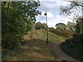
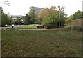
Burgess Park
A forgotten corner of the park west of Wells Way.
Image: © Derek Harper
Taken: 17 Oct 2011
0.04 miles
2
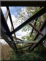
Derelict bridge, Burgess Park
Over a path in the section of park also shown in Image
Image: © Derek Harper
Taken: 17 Oct 2011
0.05 miles
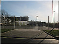
3
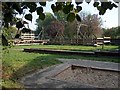
Burgess Adventure Playground, Albany Road (B214)
Image: © Noel Foster
Taken: 10 Oct 2005
0.06 miles
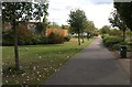
4
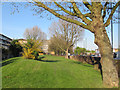
Grass verge, Albany Road
There were once terraced houses along here. The redevelopment of the area in the 1960s set the new housing blocks back from the road, leaving room for a wide verge.
Image: © Stephen Craven
Taken: 14 Apr 2015
0.06 miles
5
Burgess Park
Another photo of the neglected corner of the park west of Wells Way shown in Image Across on the left is a skateboard area. Behind are blocks of flats on Albany Road.
Image: © Derek Harper
Taken: 17 Oct 2011
0.06 miles
6
Housing on Hopwood Road, Walworth
A long block of post-war housing seen from Villa Street.
Image: © Stephen Craven
Taken: 14 Apr 2015
0.06 miles
7
Path, Burgess Park
A path heads away from the junction of Wells Way and Albany Road. But it's heading straight for the closed area of the park shown in Image On the left is the rear of Chumleigh Street cafe and playground.
Image: © Derek Harper
Taken: 17 Oct 2011
0.08 miles
8
Rear of Faraday Primary School, Walworth
The school buildings and playground seen from Villa Street. See Image for the front on Portland Street.
Image: © Stephen Craven
Taken: 14 Apr 2015
0.08 miles
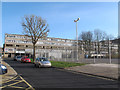
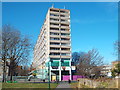
9
Chilton House, Southwark
A block of Southwark Council offices on Portland Street, seen across Burgess Park.
Image: © Stephen Craven
Taken: 1 Feb 2014
0.08 miles
10
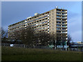
Aylesbury Estate, from Burgess Park
This photograph was taken in Burgess Park, in inner South London, looking north at one of the blocks of flats in the Aylesbury Estate.
The Aylesbury Estate was built in the early 1970s, but is due to be regenerated over the coming years.
Image: © Malc McDonald
Taken: 7 Mar 2015
0.08 miles