1
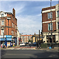
Westmoreland Street and the Red Lion pub, Walworth, south London
A wall of maisonettes on the Aylesbury Estate can be seen. The whole pub is seen in
Image
Image: © Robin Stott
Taken: 27 Aug 2016
0.02 miles
2
Aylesbury Estate regeneration
The Aylesbury Estate in south-east London was a large council estate developed in the 1960s and 1970s, housing around 7,500 people. The estate is now undergoing regeneration, which is likely to be ongoing until 2020 and beyond. One of the first parts of the estate to be demolished and rebuilt was the south-westernmost corner, with the first block completed in late 2010. The first residents are due to move into the new flats early in 2011. More homes are likely to be built on the site in the foreground.
This photo was taken from one of the walkways which linked blocks within the estate.
Image: © Malc McDonald
Taken: 22 Jan 2011
0.02 miles
3
The Red Lion pub, north end of Camberwell Road, Walworth, south London
Image: © Robin Stott
Taken: 27 Aug 2016
0.04 miles
4
Arnside Street, Walworth, south London
Seen across the north end of Camberwell Road. On the right is the Red Lion pub
Image
Image: © Robin Stott
Taken: 27 Aug 2016
0.04 miles
5
Looking towards Red Lion Row
Image: © Alex McGregor
Taken: 17 Feb 2014
0.04 miles
6
The Red Lion, Walworth
Image: © Chris Whippet
Taken: 21 Feb 2015
0.04 miles
7
Aylesbury Estate regeneration
The Aylesbury Estate, built in the 1960s and 1970s, is a large estate of council housing. It is now undergoing regeneration, which will take around 15 years to complete.
The new block nearest the camera is one of the first to be completed, in late 2010. The first residents are due to move in in early 2011. In the background is Bradenham, one of the high-rise blocks, which is eventually likely to be demolished.
Image: © Malc McDonald
Taken: 22 Jan 2011
0.04 miles
8
Flats and offices over shops and a bar, Camberwell Road, Walworth, London
Boyson Road is the turning on the right.
Image: © Robin Stott
Taken: 5 Apr 2015
0.04 miles
9
The Red Lion public house
On Walworth Road at Arnside Street (on left).
Image: © Thomas Nugent
Taken: 5 Jun 2015
0.05 miles
10
Red Lion Row
Image: © Alex McGregor
Taken: 17 Feb 2014
0.06 miles


