IMAGES TAKEN NEAR TO
Henshaw Street, LONDON, SE17 1PE
Introduction
This page details the photographs taken nearby to Henshaw Street, SE17 1PE by members of the Geograph project.
The Geograph project started in 2005 with the aim of publishing, organising and preserving representative images for every square kilometre of Great Britain, Ireland and the Isle of Man.

There are currently over 7.5m images from over14,400 individuals and you can help contribute to the project by visiting https://www.geograph.org.uk
Image Map (Loading...)


Getting Data...Please wait
Leaflet Map data © OpenStreetMap
Images are licensed for reuse under creativecommons.org/licenses/by-sa/2.0
Notes
- Clicking on the map will re-center to the selected point.
- The higher the marker number, the further away the image location is from the centre of the postcode.
Image Listing (206 Images Found)
Images are licensed for reuse under creativecommons.org/licenses/by-sa/2.0
Image
Details
Distance
1
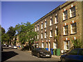
Henshaw Street, Walworth
An attractive street of 3-storey townhouses, that have outlived the later public housing of the nearby Heygate estate that was being demolished at this time.
Image: © Stephen Craven
Taken: 3 Jul 2014
0.03 miles
2
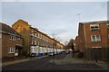
Chatham Street
From the junction with Salisbury Close.
Image: © DS Pugh
Taken: 9 Dec 2016
0.04 miles
3
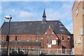
The Eternal Sacred Order of Cherubim and Seraphim Church, Walworth
51/53 Chatham Street. This is the UK Provincial headquarters of an African Instituted Church.
See http://en.wikipedia.org/wiki/Eternal_Sacred_Order_of_Cherubim_and_Seraphim for more details on this Nigerian church.
This church was part of the St John's College (Cambridge) Mission which included a hostel and parsonage on the same site. The church building opened in 1889 and was uniquely dedicated to Lady Margaret, Countess of Richmond and Derby, the co-founder of St John's college, rather than to a saint.
The church was considered for closure from 1966 and finally declared redundant by the Church of England in 1983. It has been leased from the Diocese of Southwark by the Cherubim and Seraphim church since then.
The building was listed grade 2 in 1994 (Listed Building No. 470776).
Image: © David Anstiss
Taken: 27 Nov 2009
0.05 miles
4

The Mount of Salvation Cathedral
This brick building on Chatham Street, Walworth, with an apsidal east end, is now a church of the denomination "Cherubim and Seraphim". See Image for another view.
It is listed grade 2 (list entry number 1378475) under its former name, Lady Margaret Church. It was built in 1889 as an Anglican mission, the architect being E Christian. As a parish church it was considered for closure from 1966 and the parish was united with that of St John in 1975 when it became a Chapel of Ease. It was finally declared redundant in 1983 and used from 1986 by the Cherubim & Seraphim church who have leased it from the Diocese since 1990.
Image: © Stephen Craven
Taken: 10 Jan 2013
0.06 miles
5
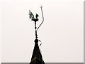
Weathercock in Walworth
The weathercock is on the fleche of the Cherubim & Seraphim church Image it is protected by a very prominent lightning conductor.
Image: © Stephen Craven
Taken: 10 Jan 2013
0.06 miles
6
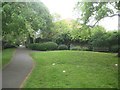
Southwark: Paragon Gardens
Paragon Gardens is a long narrow green space on the south side of the New Kent Road. It was named after The Paragon, a terrace of 15 large houses built in the form of a crescent and separated from the New Kent Road by a similarly crescent-shaped communal garden. The large houses have long since been demolished, and the shape of the original garden has been partially lost by the construction of the Bricklayers Arms roundabout. The gardens were however extended to the west here when the original housing terrace on the south side of the New Kent Road was demolished post-war.
Image: © Nigel Cox
Taken: 29 Apr 2019
0.06 miles
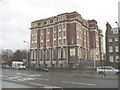
7
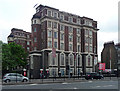
Driscoll House, New Kent Road
An imposing block in a revivalist style with a brick exterior but an early example of the use of Mouchel's iron and concrete construction method. Built as a women's hostel in 1911-13. Grade II listed.
Still a hostel, though not reserved for women, now run by Rest Up.
Image: © Stephen Richards
Taken: 6 May 2013
0.06 miles
8
An entrance into Paragon Gardens in New Kent Road
Paragon Garden is a long narrow garden on the south side of New Kent Road. It was named after The Paragon, a row of 15 large houses built in the form of a crescent and separated from the New Kent Road by a similarly crescent shaped communal garden.http://www.exploringsouthwark.co.uk/paragon-gardens/4591037119
Image: © Rod Allday
Taken: 10 Sep 2016
0.06 miles
9
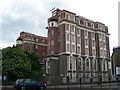
Driscoll House, 172 New Kent Road, SE1
This hotel was threatened with demolition so that a new housing development could be built on the site, but planning permission was refused. There is an application to have it given "listed" status. Follow these links to find out more http://en.wikipedia.org/wiki/Driscoll_House http://www.london-se1.co.uk/forum/read/1/40692 http://www.london-se1.co.uk/news/view/2056
Image: © Danny P Robinson
Taken: 11 May 2007
0.07 miles
10
Driscoll House, New Kent Road
Driscoll House is a Grade II listed building on the New Kent Road. It first opened as "Ada Lewis House" in 1913, offering accommodation for working women. Later it became a hotel, the Driscoll House Hotel, and more recently a student hostel. It closed in 2007, and despite local rumours that it would be demolished, was converted and sold to a developer. See also Image
(most of this information from Wikipedia: http://en.wikipedia.org/wiki/Driscoll_House )
Image: © Stephen Craven
Taken: 20 Mar 2010
0.07 miles