IMAGES TAKEN NEAR TO
Walworth Road, LONDON, SE17 1JD
Introduction
This page details the photographs taken nearby to Walworth Road, SE17 1JD by members of the Geograph project.
The Geograph project started in 2005 with the aim of publishing, organising and preserving representative images for every square kilometre of Great Britain, Ireland and the Isle of Man.

There are currently over 7.5m images from over14,400 individuals and you can help contribute to the project by visiting https://www.geograph.org.uk
Image Map
Images are licensed for reuse under creativecommons.org/licenses/by-sa/2.0
Notes
- Clicking on the map will re-center to the selected point.
- The higher the marker number, the further away the image location is from the centre of the postcode.
Image Listing (242 Images Found)
Images are licensed for reuse under creativecommons.org/licenses/by-sa/2.0
Image
Details
Distance
1
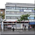
Walworth Post Office, Walworth Road, London
Image: © Robin Stott
Taken: 21 Sep 2015
0.01 miles
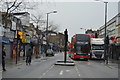
3
Walworth Road
Looking in the direction of Elephant and Castle.
Image: © Peter Trimming
Taken: 2 Mar 2017
0.03 miles
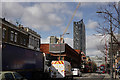
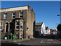
4
Buildings on the east side of Occupation Road
Just outside the area currently proposed for redevelopment.
Image: © Stephen Craven
Taken: 29 Apr 2015
0.03 miles
5
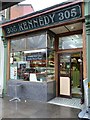
Shopfront, 305 Walworth Road, Walworth, London
Kennedy's was a chain of grocer's or butcher's shops. My wife's mother, when the family lived in West Wickham, always bought at Kennedy's. After her death, no matter at whose home we 'children' were meeting up for Christmas, a family member would make the journey to Wickham for Kennedy's pork chipolata sausages to accompany the roast bird.
This shopfront has some endearing features: the 'sunrise' motif in the upper panes of glass; polished granite, possibly, below the window; and a prettily tiled threshold. The first two items hint at a 1920s or 30s makeover, while the tiles and fascia date from an earlier period. This business is some form of eatery.
Image: © Robin Stott
Taken: 21 Sep 2015
0.04 miles
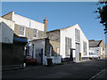
6
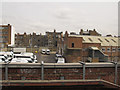
Vans in Manor Place depot
Taken to complement the ground-level views taken earlier in the week. The railway viaduct offers the only vantage point for this part of the site.
Image: © Stephen Craven
Taken: 2 May 2015
0.04 miles
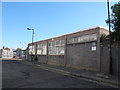
8
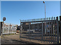
Gates to Manor Place council depot
The site will close if a proposed redevelopment of the area goes ahead (see shared description below).
Image: © Stephen Craven
Taken: 29 Apr 2015
0.04 miles
9
Buildings on the west side of Occupation Road
This side of the road is within the area currently proposed for redevelopment. This modern single-storey building appears to be one of the many sites of St Mungos Broadway (a charity for the homeless).
Image: © Stephen Craven
Taken: 29 Apr 2015
0.05 miles
10
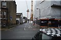
Occupation Road, Walworth
A dead-end road of Manor Place leading to the council recycling centre and a few small businesses.
Image: © Stephen Craven
Taken: 29 Apr 2015
0.05 miles