IMAGES TAKEN NEAR TO
Browning Street, LONDON, SE17 1DD
Introduction
This page details the photographs taken nearby to Browning Street, SE17 1DD by members of the Geograph project.
The Geograph project started in 2005 with the aim of publishing, organising and preserving representative images for every square kilometre of Great Britain, Ireland and the Isle of Man.

There are currently over 7.5m images from over14,400 individuals and you can help contribute to the project by visiting https://www.geograph.org.uk
Image Map
Images are licensed for reuse under creativecommons.org/licenses/by-sa/2.0
Notes
- Clicking on the map will re-center to the selected point.
- The higher the marker number, the further away the image location is from the centre of the postcode.
Image Listing (255 Images Found)
Images are licensed for reuse under creativecommons.org/licenses/by-sa/2.0
Image
Details
Distance
9
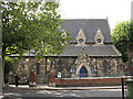
St John's church, Walworth
The church is on the corner of Larcom Street. The church was built in 1860 and is grade 2 listed.
Image: © Stephen Craven
Taken: 25 Aug 2009
0.07 miles
10

St John the Evangelist, Larcom Street, Walworth, London SE17
Image: © John Salmon
Taken: 16 Oct 2010
0.07 miles