IMAGES TAKEN NEAR TO
Brandon Street, LONDON, SE17 1AJ
Introduction
This page details the photographs taken nearby to Brandon Street, SE17 1AJ by members of the Geograph project.
The Geograph project started in 2005 with the aim of publishing, organising and preserving representative images for every square kilometre of Great Britain, Ireland and the Isle of Man.

There are currently over 7.5m images from over14,400 individuals and you can help contribute to the project by visiting https://www.geograph.org.uk
Image Map
Images are licensed for reuse under creativecommons.org/licenses/by-sa/2.0
Notes
- Clicking on the map will re-center to the selected point.
- The higher the marker number, the further away the image location is from the centre of the postcode.
Image Listing (276 Images Found)
Images are licensed for reuse under creativecommons.org/licenses/by-sa/2.0
Image
Details
Distance
1
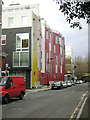
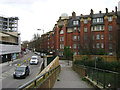
Colourful flats, 60 Brandon Street, Walworth
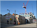
The exterior is clad in tiles, grading from yellow to dark red. The end of Charleston Street is on the left. The north end of Brandon Street and its turn west has been closed off, presumably for the duration of the demolition of the Heygate Estate and its redevelopment. The view is from outside Walters Court, walled and gated flats, perhaps almshouses?
Image: © Robin Stott
Taken: 9 Feb 2014
0.01 miles
2
Content Street, Walworth
The view includes an unusual pink-coloured building with curved walls.
Image: © Stephen Craven
Taken: 21 Oct 2014
0.02 miles
3
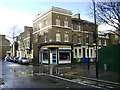
Hair and Beauty Salon, corner of Larcom Street and Brandon Street, Walworth
After a short sharp shower. Behind this the vast Heygate Estate is in course of demolition.
Image: © Robin Stott
Taken: 8 Feb 2014
0.03 miles
4
Peabody Trust flats, Walworth, Content Street frontage
The Walworth Estate first appears as Peabody Buildings on the Ordnance Survey map of 1914-21. It replaced cramped terraced houses. It's interesting that the spectacular Heygate Estate to the northwest, which appears to date from the early 1970s, is being demolished and redeveloped; Peabody housing has outlasted it.
Image: © Robin Stott
Taken: 9 Feb 2014
0.04 miles
5
English Martyrs Church Hall (temporary)
The parish hall of this Roman Catholic parish was being replaced as part of a wider redevelopment of the Walworth area. The former parish hall was closed in 2013 and this temporary hall provided in Stead Street on what was a car park. The permanent new parish hall will form the ground floor of a new development on the original site, to be completed by the summer of 2015.
source: http://carmelite.org/index.php?nuc=news&func=view&item=689
Image: © Stephen Craven
Taken: 14 Apr 2015
0.05 miles
6
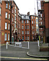
Peabody Trust flats, Walworth, courtyard off Content Street
The Walworth Estate first appears as Peabody Buildings on the Ordnance Survey map of 1914-21. It replaced cramped terraced houses. It's interesting that the spectacular Heygate Estate to the northwest, which appears to date from the early 1970s, is being demolished and redeveloped; Peabody housing has outlasted it.
Image: © Robin Stott
Taken: 9 Feb 2014
0.05 miles
8
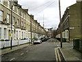
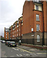
Charleston Street, Walworth
Turquand Street is on the right. Behind the camera is the Parish Church of St John the Evangelist, Walworth.
Image: © Robin Stott
Taken: 9 Feb 2014
0.05 miles
9
Peabody Trust flats, Walworth, Rodney Street frontage
The Walworth Estate first appears as Peabody Buildings on the Ordnance Survey map of 1914-21. It replaced cramped terraced houses. It's interesting that the spectacular Heygate Estate to the northwest, which appears to date from the early 1970s, is being demolished and redeveloped; Peabody housing has outlasted it.
This view is the reverse of Image
Image: © Robin Stott
Taken: 9 Feb 2014
0.05 miles
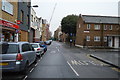
10
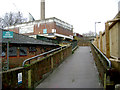
A ramp into the Heygate Estate by Rodney Road
Although most of the estate is vacated, closed off and in course of demolition and redevelopment, premises overlooking Rodney Road remain open and accessible. At the upper level are the Institute of Traditional Karate-Do and Performing Arts and, to its right, set back, the Angelus Temple of the Foursquare Gospel Church. The view is from the corner of Content Street and Rodney Road.
Image: © Robin Stott
Taken: 9 Feb 2014
0.05 miles