IMAGES TAKEN NEAR TO
Harper Road, LONDON, SE1 6AP
Introduction
This page details the photographs taken nearby to Harper Road, SE1 6AP by members of the Geograph project.
The Geograph project started in 2005 with the aim of publishing, organising and preserving representative images for every square kilometre of Great Britain, Ireland and the Isle of Man.

There are currently over 7.5m images from over14,400 individuals and you can help contribute to the project by visiting https://www.geograph.org.uk
Image Map
Images are licensed for reuse under creativecommons.org/licenses/by-sa/2.0
Notes
- Clicking on the map will re-center to the selected point.
- The higher the marker number, the further away the image location is from the centre of the postcode.
Image Listing (481 Images Found)
Images are licensed for reuse under creativecommons.org/licenses/by-sa/2.0
Image
Details
Distance
1

Brockham Street, London SE1
Attractive old terrace of houses.
Image: © Christine Matthews
Taken: 8 Mar 2015
0.02 miles
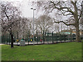
2
Green space on Harper Road
A small public open space, with no information board to give a name to it.
Image: © Stephen Craven
Taken: 6 Sep 2012
0.02 miles
3

Brockham Street, Southwark
Looking along Brockham Street from the junction with Harper Road, towards the Henry Wood Hall Image
Image: © Stephen Craven
Taken: 20 Mar 2010
0.03 miles
4
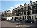
16-28 Trinity Church Square
The early-mid C19th developments in Trinity Church Square and surrounding streets are very well preserved. The terraces are handsome and uniform, in brick with stuccoed and rusticated ground floors and stuccoed window surrounds. The houses are generally of three storeys plus basements and two bays wide. These, which form the south side of the square, were built c1827. Grade II listed.
Image: © Stephen Richards
Taken: 6 May 2013
0.03 miles
5
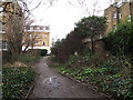
Footpath to Brockham Street
I came across this short path by chance. This is the view towards Brockham Street; behind the photographer is the car park of the Bait-ul-Aziz Islamic Centre (a large number of men were coming out after Friday prayers, but I waited until they were gone before taking the photo).
Image: © Stephen Craven
Taken: 1 Feb 2013
0.03 miles
6
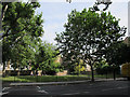
Newington Gardens
A small park at the north end of Bath Terrace. Some young men were playing football on the hard-surface sports court.
Image: © Stephen Craven
Taken: 8 Mar 2015
0.03 miles
7
Newington Gardens, London SE1
Oasis of green in this part of London.
Image: © Christine Matthews
Taken: 8 Mar 2015
0.04 miles
8
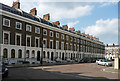
1-14 Trinity Church Square
The early-mid C19th developments in Trinity Church Square and surrounding streets are very well preserved. The terraces are handsome and uniform, in brick with stuccoed and rusticated ground floors and stuccoed window surrounds. The houses are generally of three storeys plus basements and two bays wide. These, which form the west side of the square, were built c1827. Grade II listed.
Image: © Stephen Richards
Taken: 6 May 2013
0.04 miles
9
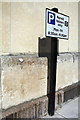
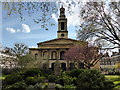
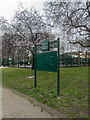
Benchmark and parking restriction sign on Holy Trinity Church
Ordnance Survey 1GL Bolt benchmark described on the Bench Mark Database at http://www.bench-marks.org.uk/bm37829
Image: © Roger Templeman
Taken: 6 May 2011
0.04 miles