IMAGES TAKEN NEAR TO
Worgan Street, LONDON, SE16 7WA
Introduction
This page details the photographs taken nearby to Worgan Street, SE16 7WA by members of the Geograph project.
The Geograph project started in 2005 with the aim of publishing, organising and preserving representative images for every square kilometre of Great Britain, Ireland and the Isle of Man.

There are currently over 7.5m images from over14,400 individuals and you can help contribute to the project by visiting https://www.geograph.org.uk
Image Map
Images are licensed for reuse under creativecommons.org/licenses/by-sa/2.0
Notes
- Clicking on the map will re-center to the selected point.
- The higher the marker number, the further away the image location is from the centre of the postcode.
Image Listing (256 Images Found)
Images are licensed for reuse under creativecommons.org/licenses/by-sa/2.0
Image
Details
Distance
3
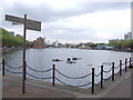
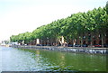
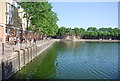
Greenland Dock
Greenland Dock regenerated.
Image: © Malc McDonald
Taken: 10 May 2010
0.03 miles
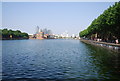

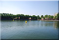
8
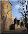
Housing by Greenland Quay
The path runs along the rear of houses on Mayflower Close to link the western end of the quay to Trident Street.
Image: © Derek Harper
Taken: 9 Feb 2011
0.04 miles