IMAGES TAKEN NEAR TO
Rope Street, LONDON, SE16 7TU
Introduction
This page details the photographs taken nearby to Rope Street, SE16 7TU by members of the Geograph project.
The Geograph project started in 2005 with the aim of publishing, organising and preserving representative images for every square kilometre of Great Britain, Ireland and the Isle of Man.

There are currently over 7.5m images from over14,400 individuals and you can help contribute to the project by visiting https://www.geograph.org.uk
Image Map (Loading...)


Getting Data...Please wait
Leaflet Map data © OpenStreetMap
Images are licensed for reuse under creativecommons.org/licenses/by-sa/2.0
Notes
- Clicking on the map will re-center to the selected point.
- The higher the marker number, the further away the image location is from the centre of the postcode.
Image Listing (234 Images Found)
Images are licensed for reuse under creativecommons.org/licenses/by-sa/2.0
Image
Details
Distance
1
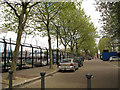
Rope Street, Rotherhithe
The street runs parallel to Greenland Dock. Maybe it was a rope walk at one time.
Image: © Stephen Craven
Taken: 19 Apr 2014
0.02 miles
2
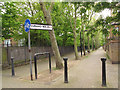
Cunard Walk, Rotherhithe
The path runs parallel to Greenland Dock and is presumably named after the liner company.
Image: © Stephen Craven
Taken: 19 Apr 2014
0.03 miles
3
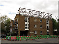
Carinthia Court, Plough Way, Rotherhithe
It is not clear what the connection is between the Austrian province of Carinthia (Kärnten) and this apartment block. Nor what the framework on top of the building is for.
Image: © Stephen Craven
Taken: 19 Apr 2014
0.03 miles
4
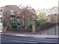
Commercial Dock Tavern pub (site of) 101, Plough Way, Rotherhithe, London, SE16
First recorded in 1861 and closed in the 1950's. Originally at the junction with Napier Terrace that later changed to Jewett Street. In the early 1960's the distance between Yeoman Street and Plough Way, where it turned south, was the thickness of the wall that separated the two i.e. about 26 inches. Plough Way did not have the extended sweep it has today as the junction with Jewett Street had been absorbed into the Surrey Docks area and blocked by a brick wall. Building to the left of the image is Carinthia Court, 93 Plough Way.
Image: © Chris Lordan
Taken: 11 Nov 2009
0.03 miles
5
Cunard Walk, Rotherhithe, SE1
Houses and walkway near Surrey Quays.
Image: © Christine Matthews
Taken: 10 Mar 2016
0.03 miles