IMAGES TAKEN NEAR TO
Plover Way, LONDON, SE16 7TT
Introduction
This page details the photographs taken nearby to Plover Way, SE16 7TT by members of the Geograph project.
The Geograph project started in 2005 with the aim of publishing, organising and preserving representative images for every square kilometre of Great Britain, Ireland and the Isle of Man.

There are currently over 7.5m images from over14,400 individuals and you can help contribute to the project by visiting https://www.geograph.org.uk
Image Map
Images are licensed for reuse under creativecommons.org/licenses/by-sa/2.0
Notes
- Clicking on the map will re-center to the selected point.
- The higher the marker number, the further away the image location is from the centre of the postcode.
Image Listing (293 Images Found)
Images are licensed for reuse under creativecommons.org/licenses/by-sa/2.0
Image
Details
Distance
1
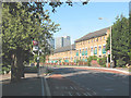
Bus stop on Redriff Road, Rotherhithe
The name of the road apparently represents a (former) local pronunciation of the place-name (Roth'riff -> Redriff?)
The bus stop in the foreground is served by routes 381 and C10.
Image: © Stephen Craven
Taken: 22 May 2010
0.01 miles
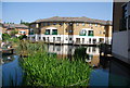
10
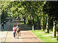
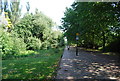
Waterman's Walk
A lovely warm day in May and a couple set off along the 400m long tree-lined path towards Russia Docks Woodland.
Image: © Stephen Craven
Taken: 22 May 2010
0.06 miles