IMAGES TAKEN NEAR TO
Greenland Quay, LONDON, SE16 7RN
Introduction
This page details the photographs taken nearby to Greenland Quay, SE16 7RN by members of the Geograph project.
The Geograph project started in 2005 with the aim of publishing, organising and preserving representative images for every square kilometre of Great Britain, Ireland and the Isle of Man.

There are currently over 7.5m images from over14,400 individuals and you can help contribute to the project by visiting https://www.geograph.org.uk
Image Map
Images are licensed for reuse under creativecommons.org/licenses/by-sa/2.0
Notes
- Clicking on the map will re-center to the selected point.
- The higher the marker number, the further away the image location is from the centre of the postcode.
Image Listing (266 Images Found)
Images are licensed for reuse under creativecommons.org/licenses/by-sa/2.0
Image
Details
Distance
1
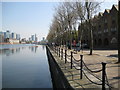
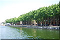
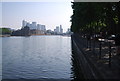
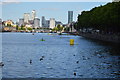
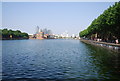
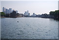
Rotherhithe: Greenland Quay, Greenland Dock, SE16
This view was taken from the south-western corner of the former Greenland Dock looking towards Canary Wharf. Greenland Dock was extended westwards to this point during the period between 1895 and 1904. The total area of the dock then reached a massive 9.1 hectares or 22.5 acres. The houses on the right overlooking the dock are on Greenland Quay.
Image: © Nigel Cox
Taken: 18 Apr 2010
0.01 miles