IMAGES TAKEN NEAR TO
Brunswick Quay, LONDON, SE16 7PX
Introduction
This page details the photographs taken nearby to Brunswick Quay, SE16 7PX by members of the Geograph project.
The Geograph project started in 2005 with the aim of publishing, organising and preserving representative images for every square kilometre of Great Britain, Ireland and the Isle of Man.

There are currently over 7.5m images from over14,400 individuals and you can help contribute to the project by visiting https://www.geograph.org.uk
Image Map
Images are licensed for reuse under creativecommons.org/licenses/by-sa/2.0
Notes
- Clicking on the map will re-center to the selected point.
- The higher the marker number, the further away the image location is from the centre of the postcode.
Image Listing (278 Images Found)
Images are licensed for reuse under creativecommons.org/licenses/by-sa/2.0
Image
Details
Distance
5
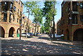
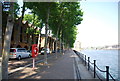
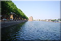
Greenland Dock
Looking across the western end of the dock to housing on Brunswick Quay. The block on the extreme left is Lock Keepers Heights.
Image: © Derek Harper
Taken: 9 Feb 2011
0.02 miles
6
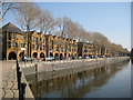
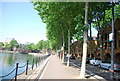
Rotherhithe: Brunswick Quay, Greenland Dock, SE16
The modern houses of Brunswick Quay now overlook the western end of Greenland Dock, which was extended this far from the Thames during the period between 1895 and 1904.
Image: © Nigel Cox
Taken: 18 Apr 2010
0.03 miles
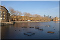
9
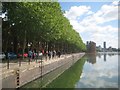
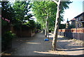
Rotherhithe: Brunswick Quay, Greenland Dock, SE16
This is an unintended near repeat of the photographer's Image] taken in April 2010. It is difficult to imagine that large cranes would have trundled up and down the dockside where the trees are now. In fact this quayside and dock is a later extension to the original Greenland Dock, and is not shown on the large scale Ordnance Survey map of 1896.
Image: © Nigel Cox
Taken: 24 May 2019
0.04 miles