IMAGES TAKEN NEAR TO
Pump House Close, LONDON, SE16 7HS
Introduction
This page details the photographs taken nearby to Pump House Close, SE16 7HS by members of the Geograph project.
The Geograph project started in 2005 with the aim of publishing, organising and preserving representative images for every square kilometre of Great Britain, Ireland and the Isle of Man.

There are currently over 7.5m images from over14,400 individuals and you can help contribute to the project by visiting https://www.geograph.org.uk
Image Map
Images are licensed for reuse under creativecommons.org/licenses/by-sa/2.0
Notes
- Clicking on the map will re-center to the selected point.
- The higher the marker number, the further away the image location is from the centre of the postcode.
Image Listing (612 Images Found)
Images are licensed for reuse under creativecommons.org/licenses/by-sa/2.0
Image
Details
Distance

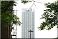
2
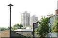
View of Regina and Columbia Points, Canada Water from the Thames Path
Looking south-southeast.
Image: © Robert Lamb
Taken: 12 Jul 2014
0.02 miles
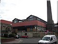
3
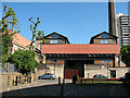
Former hydraulic pumping station (1)
This building on Renforth Street, Rotherhithe is listed Grade 2 (listed building number 471228 or Heritage asset number 1385816 as from 2011).
According to the list description, it was built in 1902 for the London Hydraulic Power Company. As well as the chimney at the right of the photo there was an "accumulator tower" (surge shaft) just visible to the left rear. All these remained in their original use until the surprisingly late date of 1977. Thereafter it was used as an engineering works and eventually converted to residential use. For another view and more history, see Image
Image: © Stephen Craven
Taken: 22 May 2010
0.02 miles
4
Former hydraulic pumping station (2)
Image: © Stephen Craven
Taken: 22 May 2010
0.02 miles
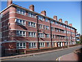
5
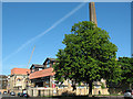
Pumping Station, Renforth Street
Built for the London Hydraulic Company in 1902-03. Grade II listed.
Now apparently flats.
The tower behind is Ontario Point.
Image: © Stephen Richards
Taken: 26 May 2013
0.02 miles
6
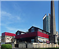
View of Maple Quays from the Thames Path
Maple Quays is a new apartment block which has been recently constructed near Canada Water station. Looking south-southeast.
Image: © Robert Lamb
Taken: 12 Jul 2014
0.02 miles
7
Housing on Renforth Street
This looked at first as if it might be part of the adjacent pumping station Image but closer examination suggests it is a contemporary building in deliberately industrial style.
Image: © Stephen Craven
Taken: 22 May 2010
0.02 miles
8
London Hydraulic Co - Renfrew Street, Rotherhithe, SE16
Signs are up, so its days could be numbered. In 1853, about where the above stands was Hales Rocket Factory owned by an inventor, William Hale. One of his inventions was a rocket and launcher extensively used in the Zulu wars and other battles. The rocket travelled without a stick and twisted like a bullet giving it greater accuracy. Before that the site was owned by Brandram Brothers where they manufactured chemicals.
Image: © Chris Lordan
Taken: 9 Sep 2009
0.03 miles
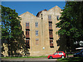
9
Aylton Estate (part), Rotherhithe, London, SE16
Built between Neptune Street, Risdon Street and Renforth Street over land that had been Risdon Street, New Street and Mary Street. There is a single block in Neptune Street and a 'U' shaped block (shown) in Renforth Street. The above block is facing an identical block that, for some reason, is officially listed as 7 to 61 Renforth Street.
Image: © Chris Lordan
Taken: 12 Oct 2009
0.03 miles
10
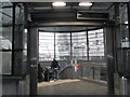
Entrance, Canada Water Underground Station
Image: © Robin Sones
Taken: 26 Feb 2013
0.04 miles