IMAGES TAKEN NEAR TO
Albatross Way, LONDON, SE16 7EB
Introduction
This page details the photographs taken nearby to Albatross Way, SE16 7EB by members of the Geograph project.
The Geograph project started in 2005 with the aim of publishing, organising and preserving representative images for every square kilometre of Great Britain, Ireland and the Isle of Man.

There are currently over 7.5m images from over14,400 individuals and you can help contribute to the project by visiting https://www.geograph.org.uk
Image Map
Images are licensed for reuse under creativecommons.org/licenses/by-sa/2.0
Notes
- Clicking on the map will re-center to the selected point.
- The higher the marker number, the further away the image location is from the centre of the postcode.
Image Listing (607 Images Found)
Images are licensed for reuse under creativecommons.org/licenses/by-sa/2.0
Image
Details
Distance
1
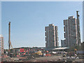
Construction site off Needleman Street
The site is to the north-west of Needleman Street and was being developed as part of RevitaliSE16. The use of long augurs (to the left and right of the photo) implies deep piled foundations and therefore a tall building to come.
Beyond the construction site is the low roof of the Canada Water bus station.
Image: © Stephen Craven
Taken: 22 May 2010
0.02 miles
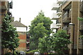
2
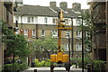
View up Providence Place from Surrey Quays Road
Looking north-northwest.
Image: © Robert Lamb
Taken: 12 Jul 2014
0.03 miles
3
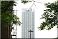
View of Maple Quays from the Thames Path
Maple Quays is a new apartment block which has been recently constructed near Canada Water station. Looking south-southeast.
Image: © Robert Lamb
Taken: 12 Jul 2014
0.04 miles
4
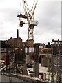
Construction site on Surrey Quays Road
Part of a large housing development on the road. One block is almost finished, this one is still at the foundation stage.
Image on Renforth Street is seen in the background.
Image: © David Anstiss
Taken: 25 Sep 2011
0.05 miles
5
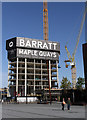
Maple Quays
A new housing development under construction close to Canada Water in Rotherhithe.
Image: © Martin Addison
Taken: 22 Apr 2012
0.05 miles

7
View up Dominion Drive from Needleman Street
Looking north-northwest.
Image: © Robert Lamb
Taken: 12 Jul 2014
0.05 miles
8
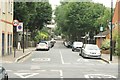
View back down Swan Road
Looking south-southeast.
Image: © Robert Lamb
Taken: 12 Jul 2014
0.05 miles
9
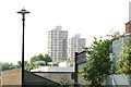
View of Regina and Columbia Points, Canada Water from the Thames Path
Looking south-southeast.
Image: © Robert Lamb
Taken: 12 Jul 2014
0.05 miles
10
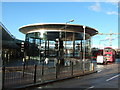
Canada Water underground station, Rotherhithe, London
Image: © Richard Humphrey
Taken: 11 Nov 2010
0.05 miles