IMAGES TAKEN NEAR TO
Canada Estate, LONDON, SE16 7BQ
Introduction
This page details the photographs taken nearby to Canada Estate, SE16 7BQ by members of the Geograph project.
The Geograph project started in 2005 with the aim of publishing, organising and preserving representative images for every square kilometre of Great Britain, Ireland and the Isle of Man.

There are currently over 7.5m images from over14,400 individuals and you can help contribute to the project by visiting https://www.geograph.org.uk
Image Map (Loading...)


Getting Data...Please wait
Leaflet Map data © OpenStreetMap
Images are licensed for reuse under creativecommons.org/licenses/by-sa/2.0
Notes
- Clicking on the map will re-center to the selected point.
- The higher the marker number, the further away the image location is from the centre of the postcode.
Image Listing (376 Images Found)
Images are licensed for reuse under creativecommons.org/licenses/by-sa/2.0
Image
Details
Distance

2
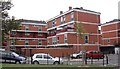
Canada Estate (part), Moodkee Street, Rotherhithe, London, SE16
Built in the late 1960s to early 1970s and so named as built close to the Canada Dock within the Surrey Commercial Docks. Comprises five "courts" each having three blocks :- Calgary : Edmonton : Manitoba : Niagara (shown) : Scotia. There are two high rise blocks, Columbia Point and Regina Point. Built on land that in 1868 contained a whitelead, sulphur and saltpetre works.
Image: © Chris Lordan
Taken: 30 Sep 2009
0.03 miles
3
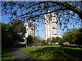
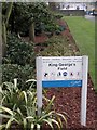
King George's Field, Rotherhithe
King George's Field is on the site of the church and churchyard of All Saints' Church. All Saints was built in 1840 and the churchyard opened in 1843 on land donated by the Lord of the Manor, Sir William Maynard Gomm, after whom nearby Gomm Road is named. The churchyard was in use until 1857 although the last recorded burial took place in 1888. All Saints was bombed during the Second World War, after which the parish was joined with that of St Mary Rotherhithe. Bermondsey Borough Council received a grant of £500 from the King George's Fields Foundation in order to procure the site after the War. The Foundation was set up as a memorial following the death of King George V in 1936, and provided funding for the creation or improvement of a great many playing fields before it was dissolved in 1965. Canada Water station is just the other side of the two tower blocks beyond the park.
Image: © Marathon
Taken: 14 Oct 2011
0.03 miles
4
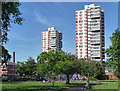
Canada Estate, Lower Road (2)
By the London County Council's Architect's Department, 1962-64. The distinctive form of the two twenty-one storey point blocks (Regina and Columbia) was widely employed in London at the time (e.g. Image]).
As seen from King George's Field.
Image: © Stephen Richards
Taken: 26 May 2013
0.04 miles
5
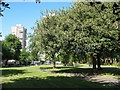
King George's Field, Rotherhithe
Many towns have an open space with this or a similar name. This one is on Lower Road, Rotherhithe - part of the old Surrey Docks area.
For a discussion on these spaces on this site, see http://www.geograph.org.uk/discuss/index.php?&action=vthread&forum=6&topic=6691&dontcount=1&page=0
Image: © Stephen Craven
Taken: 22 May 2010
0.04 miles
6
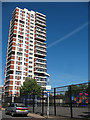
Columbia Point, Rotherhithe
One of two tower blocks dominating the Canada Estate (presumably named after Canada Water nearby). The other being Regina Point Image
In the foreground on Moodkee Street is a children's play area behind a high security fence.
Image: © Stephen Craven
Taken: 22 May 2010
0.04 miles
7
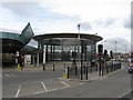
Canada Water Station, Southwark, London
LUL station on the Jubilee Line (and from 2010) the East London Line. It opened on 17 September 1999.
Image: © Richard Rogerson
Taken: 23 Mar 2009
0.05 miles
8
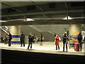
Northbound platform, Canada Water station, Rotherhithe SE16
Passengers await a London Overground train north on the former East London Line, revitalised since its extension and incorporation into the Overground Network. Canada Water is an interchange with the deep Jubilee Line extension. I had changed here to travel on towards Clapham Junction on south London suburban lines. The journeys now made possible would once have been an ordeal by bus or car.
Image: © Robin Stott
Taken: 1 Feb 2013
0.05 miles
9
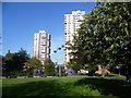
King George's Field, Rotherhithe
King George's Field is on the site of the church and churchyard of All Saints' Church. All Saints was built in 1840 and the churchyard opened in 1843 on land donated by the Lord of the Manor, Sir William Maynard Gomm, after whom nearby Gomm Road is named. The churchyard was in use until 1857 although the last recorded burial took place in 1888. All Saints was bombed during the Second World War, after which the parish was joined with that of St Mary Rotherhithe. Bermondsey Borough Council received a grant of £500 from the King George's Fields Foundation in order to procure the site after the War. The Foundation was set up as a memorial following the death of King George V in 1936, and provided funding for the creation or improvement of a great many playing fields before it was dissolved in 1965. Canada Water station is just the other side of the two tower blocks beyond the park.
Image: © Marathon
Taken: 14 Oct 2011
0.05 miles
10
King George's Field, Surrey Quays Road SE16
Image: © Robin Sones
Taken: 26 Feb 2013
0.05 miles