IMAGES TAKEN NEAR TO
Howland Estate, LONDON, SE16 7BN
Introduction
This page details the photographs taken nearby to Howland Estate, SE16 7BN by members of the Geograph project.
The Geograph project started in 2005 with the aim of publishing, organising and preserving representative images for every square kilometre of Great Britain, Ireland and the Isle of Man.

There are currently over 7.5m images from over14,400 individuals and you can help contribute to the project by visiting https://www.geograph.org.uk
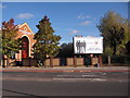
Image Map
Images are licensed for reuse under creativecommons.org/licenses/by-sa/2.0
Notes
- Clicking on the map will re-center to the selected point.
- The higher the marker number, the further away the image location is from the centre of the postcode.
Image Listing (348 Images Found)
Images are licensed for reuse under creativecommons.org/licenses/by-sa/2.0
Image
Details
Distance
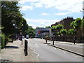
1
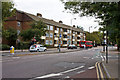
Lower Road
Seen at the junction with Ann Moss Way, looking towards the junction with Surrey Quays Road.
Image: © Martin Addison
Taken: 22 Oct 2010
0.02 miles
2
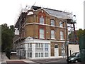
Prince of Orange pub (ex) 118, Lower Road, Rotherhithe, London, SE16
At the junction with Orange Place and first recorded in 1859 being named after the Prince of Orange (Netherlands) of the Battle of Waterloo fame. Since closing as a pub, I do not know when, it has had a second floor added at the side above the first floor.
Image: © Chris Lordan
Taken: 19 Oct 2009
0.02 miles
3
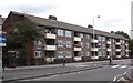
Howland Estate (part), Lower Road, Rotherhithe Street, SE16
Just south of Neptune Street and consists of two blocks - one shown is Wells House and behind it is Ritchie House. All names connected with the Great Howland Wet Dock. John Howland (son of Sir Giles) financed the dock as a dowry for his 13 year old daughter who was about to be married. Wells was the man who designed the dock and Ritchie bought the dock in 1806. In 1763 the name of the dock was changed to "Greenland Dock".
Image: © Chris Lordan
Taken: 23 Sep 2009
0.03 miles
4
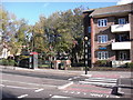
Jolly Sailor pub (site of) 91-93 Lower Road, Rotherhithe, London SE16
Located just south of Neptune Street, approximately between the telephone box and the Belisha beacon. It was a three-storeyed pub abutting the Rotherhithe Town Hall on its left. Both buildings were destroyed by a German V1 rocket on Tuesday 14th November 1944. I do not know when the final pub was built but there has been a pub on the site (or very close to), I believe with the same name, at least since 1787. The building on the right is Wells House of the Howland Estate.
Image: © Chris Lordan
Taken: 4 Nov 2009
0.03 miles
5
Crossing on the A200 beside Neptune Street Park
Image: © JThomas
Taken: 20 Jun 2022
0.03 miles

7
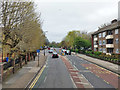
A200, Lower Road, SE16
Heading towards London Bridge.
Image: © Robin Webster
Taken: 6 Apr 2019
0.03 miles
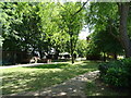
8
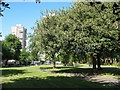
King George's Field, Rotherhithe
Many towns have an open space with this or a similar name. This one is on Lower Road, Rotherhithe - part of the old Surrey Docks area.
For a discussion on these spaces on this site, see http://www.geograph.org.uk/discuss/index.php?&action=vthread&forum=6&topic=6691&dontcount=1&page=0
Image: © Stephen Craven
Taken: 22 May 2010
0.03 miles
10
Star & Garter pub (site of) 67, Lower Road, Rotherhithe, London, SE16
The pub stood opposite Culling Road and consequently opposite the Rotherhithe Hippodrome (ex Terris Theatre). Due to the straightening of Lower Road in the late 1980's, it would have been about 10 yards beyond the wall shown. First recorded in 1859 and closed in 1941 - 'closed' I believe due to German bombs as a stick of bombs fell in that area. The Terris Theatre opened 16-10-1899 and the opening programme carried adverts, one being, "For a 'quick one' during the interval visit the Star and Garter opposite". Map of 1914 records the address as a beer retailer.
Image: © Chris Lordan
Taken: 4 Nov 2009
0.04 miles