IMAGES TAKEN NEAR TO
Canada Estate, LONDON, SE16 7BE
Introduction
This page details the photographs taken nearby to Canada Estate, SE16 7BE by members of the Geograph project.
The Geograph project started in 2005 with the aim of publishing, organising and preserving representative images for every square kilometre of Great Britain, Ireland and the Isle of Man.

There are currently over 7.5m images from over14,400 individuals and you can help contribute to the project by visiting https://www.geograph.org.uk
Image Map
Images are licensed for reuse under creativecommons.org/licenses/by-sa/2.0
Notes
- Clicking on the map will re-center to the selected point.
- The higher the marker number, the further away the image location is from the centre of the postcode.
Image Listing (361 Images Found)
Images are licensed for reuse under creativecommons.org/licenses/by-sa/2.0
Image
Details
Distance
1
Canada Estate, Lower Road (2)
By the London County Council's Architect's Department, 1962-64. The distinctive form of the two twenty-one storey point blocks (Regina and Columbia) was widely employed in London at the time (e.g. Image]).
As seen from King George's Field.
Image: © Stephen Richards
Taken: 26 May 2013
0.01 miles
2
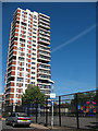
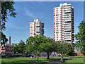
Columbia Point, Rotherhithe
One of two tower blocks dominating the Canada Estate (presumably named after Canada Water nearby). The other being Regina Point Image
In the foreground on Moodkee Street is a children's play area behind a high security fence.
Image: © Stephen Craven
Taken: 22 May 2010
0.01 miles
3
Rotherhithe: Columbia Point and Regina Point, Canada Estate, SE16
Columbia Point, to the left, and Regina Point, to the right, are twin tower blocks on the Canada Estate that currently dominate the Surrey Quays horizon. They each house 80 flats arranged on 20 floors and were completed in 1964. They are about 62 metres or about 203 feet high from ground level to the parapet.
Image: © Nigel Cox
Taken: 18 Apr 2010
0.01 miles
4
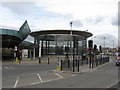
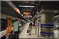
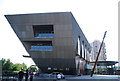
Canada Water Station, Southwark, London
LUL station on the Jubilee Line (and from 2010) the East London Line. It opened on 17 September 1999.
Image: © Richard Rogerson
Taken: 23 Mar 2009
0.01 miles
5
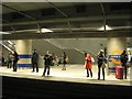
Northbound platform, Canada Water station, Rotherhithe SE16
Passengers await a London Overground train north on the former East London Line, revitalised since its extension and incorporation into the Overground Network. Canada Water is an interchange with the deep Jubilee Line extension. I had changed here to travel on towards Clapham Junction on south London suburban lines. The journeys now made possible would once have been an ordeal by bus or car.
Image: © Robin Stott
Taken: 1 Feb 2013
0.01 miles
6
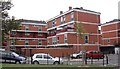
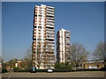
Canada Estate (part), Moodkee Street, Rotherhithe, London, SE16
Built in the late 1960s to early 1970s and so named as built close to the Canada Dock within the Surrey Commercial Docks. Comprises five "courts" each having three blocks :- Calgary : Edmonton : Manitoba : Niagara (shown) : Scotia. There are two high rise blocks, Columbia Point and Regina Point. Built on land that in 1868 contained a whitelead, sulphur and saltpetre works.
Image: © Chris Lordan
Taken: 30 Sep 2009
0.02 miles
7
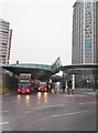
Canada Water Bus Depot, Surrey Quays Road SE16
Image: © Robin Sones
Taken: 26 Feb 2013
0.03 miles
9
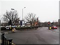
Surrey Quays Road SE16
At the junction with Deal Porters Way
Image: © Robin Sones
Taken: 26 Feb 2013
0.03 miles