IMAGES TAKEN NEAR TO
Woodland Crescent, LONDON, SE16 6YP
Introduction
This page details the photographs taken nearby to Woodland Crescent, SE16 6YP by members of the Geograph project.
The Geograph project started in 2005 with the aim of publishing, organising and preserving representative images for every square kilometre of Great Britain, Ireland and the Isle of Man.

There are currently over 7.5m images from over14,400 individuals and you can help contribute to the project by visiting https://www.geograph.org.uk
Image Map
Images are licensed for reuse under creativecommons.org/licenses/by-sa/2.0
Notes
- Clicking on the map will re-center to the selected point.
- The higher the marker number, the further away the image location is from the centre of the postcode.
Image Listing (333 Images Found)
Images are licensed for reuse under creativecommons.org/licenses/by-sa/2.0
Image
Details
Distance
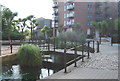
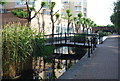
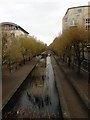
3
Path beside Albion Water
Formerly a commercial canal between docks, Albion Water has been landscaped into an amenity waterway.
Image: © Des Blenkinsopp
Taken: 22 May 2018
0.03 miles
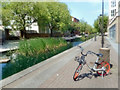
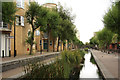
6
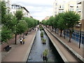
Albion Channel, Surrey Quays
As seen from Surrey Quays Road.
This was a canal linking Surrey Water (near the River Thames) with Canada Dock (now Canada Water) and Greenland Dock. Now remains as a water feature and walkway within the redeveloped area.
Image: © David Anstiss
Taken: 25 Sep 2011
0.03 miles
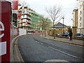
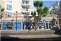
8
Needleman Street, Rotherhithe
The contemporary housing in the background is on Garter Way. The shared-use (cycle/pedestrian) sign to the right of the photo marks the line of Albatross Way which crosses Needleman Street at this point, one of several such traffic-free paths on the Rotherhithe peninsula.
Image: © Stephen Craven
Taken: 22 May 2010
0.04 miles
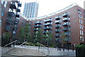
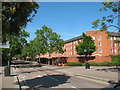
10
Albion Channel
Properties on Garter Way and Albion Channel, an artefact of the former Albion Dock, part of the Surrey Commercial Docks complex. It now links the former Surrey Canal Docks Basin with Canada Water, the lake created from the former Canada Dock.
Image: © Richard Croft
Taken: 16 Aug 2011
0.05 miles