IMAGES TAKEN NEAR TO
Wolfe Crescent, LONDON, SE16 6SS
Introduction
This page details the photographs taken nearby to Wolfe Crescent, SE16 6SS by members of the Geograph project.
The Geograph project started in 2005 with the aim of publishing, organising and preserving representative images for every square kilometre of Great Britain, Ireland and the Isle of Man.

There are currently over 7.5m images from over14,400 individuals and you can help contribute to the project by visiting https://www.geograph.org.uk
Image Map
Images are licensed for reuse under creativecommons.org/licenses/by-sa/2.0
Notes
- Clicking on the map will re-center to the selected point.
- The higher the marker number, the further away the image location is from the centre of the postcode.
Image Listing (236 Images Found)
Images are licensed for reuse under creativecommons.org/licenses/by-sa/2.0
Image
Details
Distance
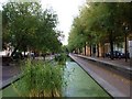
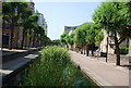
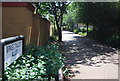
2
Sitting Out by Albion Water
This former canal is now a pleasant open corridor between residential streets.
Image: © Des Blenkinsopp
Taken: 22 May 2018
0.01 miles
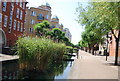
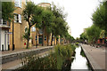
5
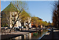
Albion Channel
A water feature connecting Surrey Water with Canada Water and constructed as part of the redevelopment of the area which was badly bombed during World War II. The channel, although looking like a canal, is not navigable. The octagonal apartment blocks on the left of the channel are Adelphi Court and Aberdale Court.
Image: © Martin Addison
Taken: 22 Apr 2012
0.02 miles
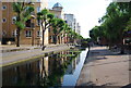
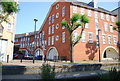
6
Albion Channel footbridge, Surrey Quays
This was a canal linking Surrey Water (near the River Thames) with Canada Dock (now Canada Water) and Greenland Dock. Now remains as a water feature and walkway within the redeveloped area.
Image: © David Anstiss
Taken: 25 Sep 2011
0.02 miles
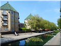
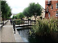
8
Albion Channel
Properties on Garter Way and Albion Channel, an artefact of the former Albion Dock, part of the Surrey Commercial Docks complex. It now links the former Surrey Canal Docks Basin with Canada Water, the lake created from the former Canada Dock.
Image: © Richard Croft
Taken: 16 Aug 2011
0.03 miles