IMAGES TAKEN NEAR TO
Christopher Close, LONDON, SE16 6PG
Introduction
This page details the photographs taken nearby to Christopher Close, SE16 6PG by members of the Geograph project.
The Geograph project started in 2005 with the aim of publishing, organising and preserving representative images for every square kilometre of Great Britain, Ireland and the Isle of Man.

There are currently over 7.5m images from over14,400 individuals and you can help contribute to the project by visiting https://www.geograph.org.uk
Image Map
Images are licensed for reuse under creativecommons.org/licenses/by-sa/2.0
Notes
- Clicking on the map will re-center to the selected point.
- The higher the marker number, the further away the image location is from the centre of the postcode.
Image Listing (356 Images Found)
Images are licensed for reuse under creativecommons.org/licenses/by-sa/2.0
Image
Details
Distance
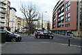
1
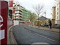
Needleman Street, Rotherhithe
The contemporary housing in the background is on Garter Way. The shared-use (cycle/pedestrian) sign to the right of the photo marks the line of Albatross Way which crosses Needleman Street at this point, one of several such traffic-free paths on the Rotherhithe peninsula.
Image: © Stephen Craven
Taken: 22 May 2010
0.02 miles
2
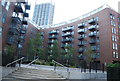
Fairway Court, Needleman Street
Relatively new housing (late 20th century), but in a style that echoes the former dock buildings in this part of Rotherhithe, with wide, arched windows and even the suggestion of a former hoist door in one gable.
Image: © Stephen Craven
Taken: 22 May 2010
0.02 miles
7
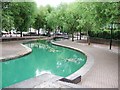
Albion Channel
This ornamental canal runs between two former docks, which are now isolated from the Thames.
Image: © Timothy Baldwin
Taken: 9 Jul 2006
0.07 miles
8
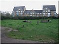
Open space
With some rudimentary play facilities and possibly remains of others.
Image: © Hugh Venables
Taken: 13 Apr 2008
0.07 miles
10
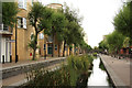
Albion Channel
Properties on Garter Way and Albion Channel, an artefact of the former Albion Dock, part of the Surrey Commercial Docks complex. It now links the former Surrey Canal Docks Basin with Canada Water, the lake created from the former Canada Dock.
Image: © Richard Croft
Taken: 16 Aug 2011
0.07 miles