IMAGES TAKEN NEAR TO
Buckters Rents, LONDON, SE16 6NA
Introduction
This page details the photographs taken nearby to Buckters Rents, SE16 6NA by members of the Geograph project.
The Geograph project started in 2005 with the aim of publishing, organising and preserving representative images for every square kilometre of Great Britain, Ireland and the Isle of Man.

There are currently over 7.5m images from over14,400 individuals and you can help contribute to the project by visiting https://www.geograph.org.uk
Image Map
Images are licensed for reuse under creativecommons.org/licenses/by-sa/2.0
Notes
- Clicking on the map will re-center to the selected point.
- The higher the marker number, the further away the image location is from the centre of the postcode.
Image Listing (250 Images Found)
Images are licensed for reuse under creativecommons.org/licenses/by-sa/2.0
Image
Details
Distance
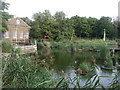
1

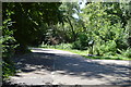
Lavender Pond Nature Park
Lavender Pond Nature Park was established in 1981 on the site of the much larger Lavender Pond which was part of the former Surrey Commercial Docks. The map from before the First World War shows its site as the canal linking Lavender Lock to the much larger Lavender Pond - see https://maps.nls.uk/geo/explore/#zoom=17.4&lat=51.50657&lon=-0.03575&layers=257&b=1&o=100
Lavender Pond Nature Park is home to a wildlife pond, wet meadows and a woodland area. See https://cityseeker.com/london/862242-lavender-pond-nature-park
Image: © Marathon
Taken: 25 Jun 2024
0.05 miles
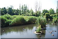
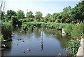
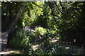
7

Lavender Pond Nature Park
Lavender Pond Nature Park was established in 1981 on the site of the much larger Lavender Pond which was part of the former Surrey Commercial Docks. The map from before the First World War shows its site as the canal linking Lavender Lock to the much larger Lavender Pond - see https://maps.nls.uk/geo/explore/#zoom=17.4&lat=51.50657&lon=-0.03575&layers=257&b=1&o=100
Lavender Pond Nature Park is home to a wildlife pond, wet meadows and a woodland area. See https://cityseeker.com/london/862242-lavender-pond-nature-park
Image: © Marathon
Taken: 25 Jun 2024
0.07 miles
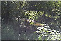
8
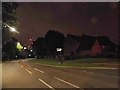
Salter Road, Rotherhithe
The red lights in the distance are from Canary Wharf
Image: © David Howard
Taken: 12 Aug 2017
0.07 miles
10
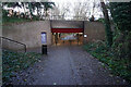
Turf Zone "Salterside"
Nelson Walk at Salter Road, Rotherhithe, London.
Image: © Ian S
Taken: 24 Dec 2022
0.08 miles