IMAGES TAKEN NEAR TO
Steers Way, LONDON, SE16 6HP
Introduction
This page details the photographs taken nearby to Steers Way, SE16 6HP by members of the Geograph project.
The Geograph project started in 2005 with the aim of publishing, organising and preserving representative images for every square kilometre of Great Britain, Ireland and the Isle of Man.

There are currently over 7.5m images from over14,400 individuals and you can help contribute to the project by visiting https://www.geograph.org.uk
Image Map
Images are licensed for reuse under creativecommons.org/licenses/by-sa/2.0
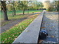
Notes
- Clicking on the map will re-center to the selected point.
- The higher the marker number, the further away the image location is from the centre of the postcode.
Image Listing (246 Images Found)
Images are licensed for reuse under creativecommons.org/licenses/by-sa/2.0
Image
Details
Distance
1
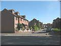
Somerford Way, Rotherhithe
A street of modern housing off Downtown Road.
Image: © Stephen Craven
Taken: 22 May 2010
0.02 miles
2

Housing Estate, Rotherhithe, SE1
Image: © Christine Matthews
Taken: 10 Mar 2016
0.05 miles
3
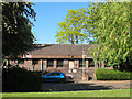
Surrey Docks Health Centre
From this angle, the building on Downtown Road, Rotherhithe appeared disused with the entrance door boarded up, but it still appears on an NHS website and others to be functioning, so presumably there is another entrance round the other side.
Image: © Stephen Craven
Taken: 22 May 2010
0.06 miles
4
Salter Road at the junction of Downtown Road
Image: © David Howard
Taken: 12 Aug 2017
0.06 miles
5
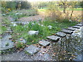
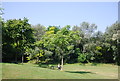
Stepping stones at Russia Dock Woodland
Russia Dock was part of the Surrey Commercial Docks and was originally used for the importing of timber from Norway, Russia and Sweden. The soft wood was mostly used for paper for prints and for furniture. Following the closure of the Surrey Commercial Docks in the 1970s, Russia Dock was in filled in 1980, apart from a thin 'stream', and planted as a woodland in the same year. A series of water channels and ponds provided habitats for kingfishers and herons. It still contains surviving dock features including the retaining wall capstones, depth gauges, bollards, mooring chains and tracks. Here the stream passes from a pond to a marsh and a set of stepping stones have been provided.
Image: © Marathon
Taken: 9 Nov 2011
0.07 miles
6
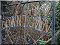
Overgrown Gate, Downton Road, Rotherhithe, SE1
Image: © Christine Matthews
Taken: 10 Mar 2016
0.07 miles
7
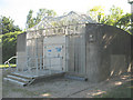
Electrical installation on Downtown Road
A very heavily guarded substation: OpenStreetMap shows a shaft to the Jubilee Line here, so perhaps this is the electrical supply to the trains, or powering ventilation fans?
Image: © Stephen Craven
Taken: 22 May 2010
0.07 miles
8
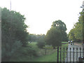
Russia Dock Woodland
One of the large Surrey Docks, Russia Dock was infilled and grassed over to make an urban woodland. The main path through the woods (right) was the dockside and the crane rails are still visible.
Image: © Stephen Craven
Taken: 4 Jul 2006
0.08 miles
9
The old dockside and a bollard at Russia Dock Woodland
Russia Dock was part of the Surrey Commercial Docks and was originally used for the importing of timber from Norway, Russia and Sweden. The soft wood was mostly used for paper for prints and for furniture. Following the closure of the Surrey Commercial Docks in the 1970s, Russia Dock was in filled in 1980, apart from a thin 'stream', and planted as a woodland in the same year. A series of water channels and ponds provided habitats for kingfishers and herons. It still contains surviving dock features including the retaining wall, capstones, depth gauges, bollards, mooring chains and tracks.
Image: © Marathon
Taken: 9 Nov 2011
0.08 miles