IMAGES TAKEN NEAR TO
Hull Close, LONDON, SE16 6BY
Introduction
This page details the photographs taken nearby to Hull Close, SE16 6BY by members of the Geograph project.
The Geograph project started in 2005 with the aim of publishing, organising and preserving representative images for every square kilometre of Great Britain, Ireland and the Isle of Man.

There are currently over 7.5m images from over14,400 individuals and you can help contribute to the project by visiting https://www.geograph.org.uk
Image Map
Images are licensed for reuse under creativecommons.org/licenses/by-sa/2.0
Notes
- Clicking on the map will re-center to the selected point.
- The higher the marker number, the further away the image location is from the centre of the postcode.
Image Listing (175 Images Found)
Images are licensed for reuse under creativecommons.org/licenses/by-sa/2.0
Image
Details
Distance
1
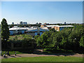
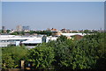
Bacon's College, Rotherhithe
Bacon's College was opened in 1991 as an all-ability 11-19 school built in the heart of the London Docklands on a 'Brown Field' site. [information from the school website: http://www.baconscollege.co.uk/ ]
This is a view from the top of Stave Hill Image
Image: © Stephen Craven
Taken: 22 May 2010
0.06 miles
2
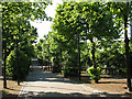
Dock Hill Avenue
The avenue is a traffic-free walking/cycling path that leads in a straight line for 430m from Stave Hill Image to Surrey Water Image
Image: © Stephen Craven
Taken: 22 May 2010
0.08 miles
3
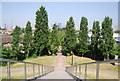
View NW from Stave Hill
The City in the distance.
Image: © N Chadwick
Taken: 7 Jul 2013
0.09 miles
4
From Stave Hill, looking towards the City of London
Stave Hill is an artificial mound beside an ecology park, see; http://en.wikipedia.org/wiki/Stave_Hill
Image: © Chris Morgan
Taken: 16 Jul 2012
0.09 miles
6
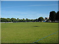
Playing fields off Timber Pond Road
The playing fields are close to Bacon College, so may belong to (or at least be used by) the school.
Image: © Stephen Craven
Taken: 22 May 2010
0.10 miles
7
Dockhill Avenue, Surrey Water
This path leads from the former dock towards Stave Hill.
Image: © David Anstiss
Taken: 25 Sep 2011
0.10 miles
8
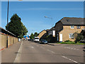
Lagado Mews, Rotherhithe
Typical of the modern (1990s-2000s) housing built in the former docklands on the Rotherhithe peninsula. The road is surfaced with brick paviours, a material that looks more pleasing visually than the usual bitumen macadam but is less rough than traditional setts.
Image: © Stephen Craven
Taken: 23 May 2010
0.11 miles
9
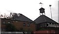
Ex Fisher Football club house, Salter Road, Rotherhithe, London, SE16
Built with the redevelopment of the Surrey Docks in the early 1980's. Later became a school for wayward children (so I understand) and gutted by fire prior to 2005. Fisher Club, that originated in Fair Street, Bermondsey, London, SE1, was founded by a Roman Catholic priest for boys of the area.
Image: © Chris Lordan
Taken: 23 Sep 2009
0.12 miles
10
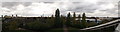
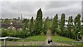
Panorama from Stave Hill (2)
As seen from the top of Image
Looking westwards towards central London.
The Shard is in the middle. On the right is Image, leading towards Image
On the far right is Image
Image: © David Anstiss
Taken: 25 Sep 2011
0.12 miles