IMAGES TAKEN NEAR TO
Marlow Way, LONDON, SE16 6AH
Introduction
This page details the photographs taken nearby to Marlow Way, SE16 6AH by members of the Geograph project.
The Geograph project started in 2005 with the aim of publishing, organising and preserving representative images for every square kilometre of Great Britain, Ireland and the Isle of Man.

There are currently over 7.5m images from over14,400 individuals and you can help contribute to the project by visiting https://www.geograph.org.uk
Image Map
Images are licensed for reuse under creativecommons.org/licenses/by-sa/2.0
Notes
- Clicking on the map will re-center to the selected point.
- The higher the marker number, the further away the image location is from the centre of the postcode.
Image Listing (244 Images Found)
Images are licensed for reuse under creativecommons.org/licenses/by-sa/2.0
Image
Details
Distance
1
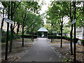
Dockhill Avenue, Surrey Water
This path leads from the former dock towards Stave Hill.
Image: © David Anstiss
Taken: 25 Sep 2011
0.03 miles
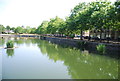
5
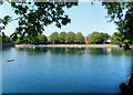
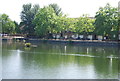
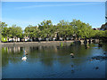
Surrey Water
A former dock now an urban lake.
Image: © Des Blenkinsopp
Taken: 22 May 2018
0.05 miles
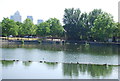
8
Surrey Waters
Former Docks, now water feature within a housing development.
Seen from near Dockhill Avenue.
Image: © David Anstiss
Taken: 25 Sep 2011
0.06 miles
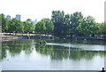
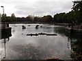
9
Surrey Water, southern end
Looking towards the entrance of the Albion Channel that connects Surrey Water to Canada Water - two of the few remaining parts of the Surrey Docks that were not filled in.
Image: © Stephen Craven
Taken: 22 May 2010
0.06 miles
10
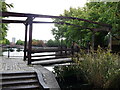
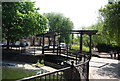
Bridge near Surrey Water
This bridge leads over Albion Canal, which was a canal linking Surrey Water (near the River Thames) with Canada Dock (now Canada Water) and Greenland Dock. Now remains as a water feature and walkway within the redeveloped area.
Image: © David Anstiss
Taken: 25 Sep 2011
0.06 miles