IMAGES TAKEN NEAR TO
Rotherhithe Street, LONDON, SE16 5UB
Introduction
This page details the photographs taken nearby to Rotherhithe Street, SE16 5UB by members of the Geograph project.
The Geograph project started in 2005 with the aim of publishing, organising and preserving representative images for every square kilometre of Great Britain, Ireland and the Isle of Man.

There are currently over 7.5m images from over14,400 individuals and you can help contribute to the project by visiting https://www.geograph.org.uk
Image Map
Images are licensed for reuse under creativecommons.org/licenses/by-sa/2.0
Notes
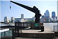
- Clicking on the map will re-center to the selected point.
- The higher the marker number, the further away the image location is from the centre of the postcode.
Image Listing (349 Images Found)
Images are licensed for reuse under creativecommons.org/licenses/by-sa/2.0
Image
Details
Distance
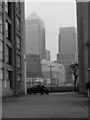
3
View of Lawrence Wharf from Mackenzie Walk
Looking west.
Image: © Robert Lamb
Taken: 13 Aug 2017
0.02 miles
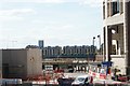
4
View of towerblocks in Deptford from Canary Riverside #2
Looking south-southwest.
Image: © Robert Lamb
Taken: 13 Aug 2017
0.02 miles
6
View of Rotherhithe from West India Avenue
Looking south-southwest.
Image: © Robert Lamb
Taken: 13 Aug 2017
0.02 miles
8
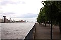
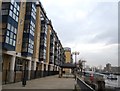
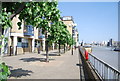
Tree lined Lawrence Wharf
The Thames Path runs along Lawrence Wharf.
Image: © Steve Daniels
Taken: 25 Jun 2012
0.02 miles
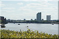
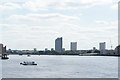
9
A view to Canary Wharf from the other side of the river
Image: © Eirian Evans
Taken: 28 Nov 2013
0.02 miles
10
View of towerblocks in Deptford from Canary Riverside #3
Looking south-southwest.
Image: © Robert Lamb
Taken: 13 Aug 2017
0.02 miles